




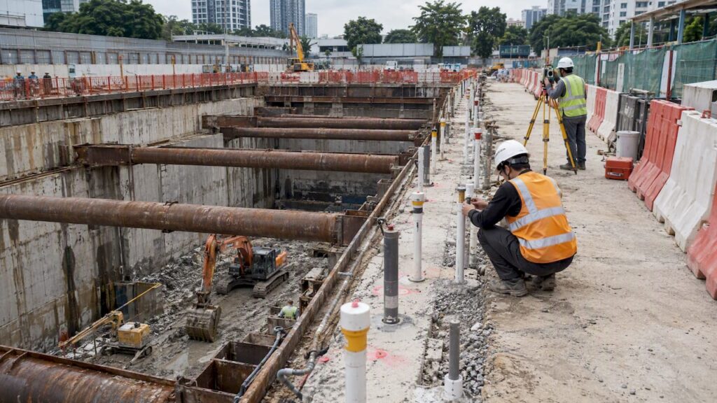
Geotechnical instrumentation and monitoring give engineers measured, continuous evidence of how ground and structures respond to construction, allowing teams to protect adjacent buildings, meet BCA guidance for excavation and retaining systems, and catch warning signs before they become failures. For Singapore projects, this means pairing the right instruments with disciplined arrays, clear alarm thresholds, and a documented escalation chain, all of which we outline below alongside the regulatory references practitioners rely on.
TL;DR:
- Instrumentation spacing should be around 30 to 40 meters along retaining walls, with increased density at weak points and near utilities or sensitive structures.
- Real-time data collection is essential for high-risk excavations in sensitive areas, while lower-risk projects can rely on daily or weekly manual readings.
- The Qualified Person and accredited checker jointly oversee alarm thresholds and instrumentation adequacy, ensuring immediate work stoppage if critical limits are exceeded.
- Geophysical surveys, such as resistivity and microgravity, should guide borehole placement, especially in limestone or reclaimed ground, to identify hidden weak zones.
- A comprehensive instrumentation plan, including arrays, thresholds, and contingency measures, is vital for early warning and effective site safety and productivity.
Table of Contents
- Common instrument types and what each measures
- Designing monitoring arrays and placement: practical Singapore guidance
- Installation, data logging, telemetry and reading frequency
- Roles, alarm thresholds and escalation: who does what when readings exceed limits
- How site investigation and geophysics inform instrument selection
- Practitioner checklist and common pitfalls
- Why good instrumentation is a productivity and safety win
- FAQ
- Sources
- Get specialist support for your instrumentation plan
Common instrument types and what each measures
Choosing the right instrument starts with knowing what each one is built to detect. Most Singapore excavation and tunneling projects draw from a core set of sensors, each suited to a specific failure mode or ground response.
- Inclinometers (in-wall and in-ground) track lateral movement and wall deflection along retaining structures.
- Piezometers, whether vibrating-wire or standpipe type, measure pore water pressure and groundwater behavior that influence excavation stability.
- Settlement markers and deep settlement points record ground and structure settlement over time.
- Strain gauges, vibrating-wire strain gauges (VWSG), and load cells quantify structural and strut loads during staged excavation.
- Tiltmeters, crack monitors, extensometers, vibration meters, and temperature sensors cover secondary risks such as building tilt, crack propagation, ground extension, and construction vibration.
LTA’s civil standards on instrumentation lists these instrument categories alongside guidance on when automatically logged instruments and telemetry are warranted, typically for high-risk works where manual readings cannot keep pace with ground behavior.
Designing monitoring arrays and placement: practical Singapore guidance
A single instrument rarely tells the full story. The cluster principle, combining an inclinometer, a piezometer or water standpipe, and settlement markers at the same location, lets engineers cross-check readings and separate genuine ground movement from sensor drift or seasonal groundwater change.
For excavation and retaining system (ERSS) works, the BCA circular on sheet-pile integrity sets expectations for excavations deeper than six meters.
Instrument clusters should sit at roughly 30 to 40 meter intervals along the ERSS wall, with denser placement required at weak points such as utility crossings or sections adjacent to existing structures. The same circular mandates contingency measures and construction supervision as part of the submitted instrumentation plan.
- Tighten spacing in limestone zones, reclaimed soils, or near structures with shallow foundations.
- Add extra settlement points where utility trenches interrupt a continuous wall run.
- Document every instrument’s coordinates, elevation datum, and reading schedule in the instrumentation plan itself, not as a separate attachment.
Our ERSS design guidance covers how these array decisions tie back to the excavation’s risk category.
Installation, data logging, telemetry and reading frequency
Good instrumentation only produces trustworthy data when the groundwork is sound. Before any excavation starts, we recommend a baseline condition survey of adjacent buildings, roads, and utilities, establishing the datum against which every later reading is compared. Without this baseline, teams cannot tell whether a crack or a settlement reading predates construction or resulted from it.
Automatic data-collection and real-time telemetry suit tunneling works, deep basements near sensitive structures, and any site where a delayed reading could mean a missed warning. Manual readings remain adequate for lower-risk works with stable ground conditions.
- Real-time or hourly readings suit tunnel drives and high-risk excavations near critical infrastructure.
- Daily or weekly readings often suffice for shallower works with wide buffers from adjacent structures.
- Calibration records and maintenance logs should accompany every instrument from installation through decommissioning.
- Recordkeeping should capture raw readings, processed trends, and any instrument replacement or recalibration event.
Pro Tip: Build redundancy into critical monitoring channels so a single faulty sensor never leaves a work-stop decision resting on one unverified reading.
LTA’s Chapter 13 standards detail monitoring arrays and reading frequency specifically for tunnels and transport infrastructure, favoring real-time monitoring for the most critical works.
Roles, alarm thresholds and escalation: who does what when readings exceed limits
Instrumentation data is only as useful as the response it triggers. Singapore practice assigns clear responsibilities across the project team, and accredited checkers carry a formal duty to review the adequacy of instrumentation type, location, number, and reporting frequency before works proceed.
- The Qualified Person sets the instrumentation plan, alarm levels, and trigger values based on the design’s assumptions.
- The accredited checker reviews whether the instrumentation plan matches the ground conditions and excavation risk.
- The builder installs, maintains, and reads instruments according to the approved schedule, reporting results promptly.
- When a critical instrument exceeds its alert or alarm level, work stops immediately on the affected section pending engineering review.
- The project team follows a documented communication chain so that an exceedance reaches decision-makers without delay.
A communication and escalation study notes that gaps in reporting chains remain among the most common reasons monitoring programs fail to prevent incidents, even when the instruments themselves perform correctly. Our article on QP(S) oversight covers how this oversight structure functions across a project’s lifecycle.
How site investigation and geophysics inform instrument selection
Instrumentation plans are only as good as the ground model behind them. Borehole spacing and site investigation scope set the foundation for deciding where instruments go and what they need to detect.
In limestone areas, the BCA/IES/ACES/GEOSS guideline on bored piling recommends geophysical survey methods to detect cavities and karstic features that boreholes alone might miss between sampling points.
- Electrical resistivity tomography, MASW, and microgravity surveys help target where intrusive site investigation should concentrate.
- Geophysics guides borehole placement but never replaces it. Findings from each method should calibrate the other iteratively.
- In reclaimed or soft ground, wider geophysical scans combined with closely spaced boreholes reduce the risk of missing a weak zone.
- Sharing invasive SI results with the geophysics contractor lets both datasets refine the final instrumentation layout before installation begins.
Our site investigation guidance and background on soil improvement in challenging ground expand on how these findings shape foundation and instrumentation decisions together.
Practitioner checklist and common pitfalls
Across the projects we review, the same oversights tend to resurface regardless of project scale. A short checklist helps teams avoid the costliest ones.
- Complete a pre-construction baseline survey of every adjacent structure and utility before mobilization begins.
- Write explicit alarm and alert thresholds, along with the contingency action for each, directly into the instrumentation plan.
- Specify telemetry for high-risk and high-consequence works, with redundancy on any channel feeding a stop-work decision.
- Confirm installation tolerances, calibration certificates, and QA sign-off are included in the tender specification, not left to the installer’s discretion.
- Schedule maintenance and recalibration intervals in the contract, not as an afterthought once instruments are live.
Pro Tip: Treat the instrumentation plan as a living document: update alarm levels and array density as early readings confirm or challenge the ground model’s assumptions.
Why good instrumentation is a productivity and safety win
Instrumentation data does more than satisfy a compliance checklist. When readings consistently confirm that ground behavior tracks or outperforms design assumptions, that evidence supports Observational Method decisions, including the kind documented in a Singapore deep-excavation case history, where monitoring data allowed the project to omit a third level of struts and still meet performance requirements.
The real payoff is not the sensor count. It is the speed and confidence of the decisions a clear escalation chain enables. Projects that pair competent instrumentation specialists with documented roles and thresholds move faster when conditions behave, and stop faster when they don’t.
— Aman
FAQ
What is geotechnical instrumentation in Singapore construction?
Geotechnical instrumentation refers to sensors and monitoring systems, such as inclinometers, piezometers, and settlement markers, that track how ground and structures respond during excavation, piling, or tunneling works. In Singapore, this data supports compliance with BCA and LTA guidance and gives engineers early warning of movement that could affect adjacent buildings.
How often should monitoring instruments be read on a Singapore site?
Reading frequency depends on risk level: tunnels and high-risk excavations near sensitive structures often use real-time or hourly telemetry, while lower-risk works may only need daily or weekly manual readings. LTA’s instrumentation standards detail these expectations for transport infrastructure projects specifically.
Who is responsible for setting alarm thresholds on an ERSS project?
The Qualified Person sets the instrumentation plan and alarm or trigger levels based on design assumptions, while the accredited checker reviews whether the plan matches the site’s actual risk. The BCA circular on sheet-pile integrity requires contingency measures to be built into this plan for excavations deeper than 6 meters.
Why do limestone areas need extra geophysical survey work?
Limestone ground can hide cavities and karstic features that boreholes alone may miss between sampling points, which is why the BCA/IES/ACES/GEOSS guideline recommends geophysical methods alongside intrusive site investigation. Combining both datasets iteratively gives a more reliable ground model before instruments are installed.
Can instrumentation data reduce construction costs on a project?
Instrumentation data can support Observational Method decisions where monitoring confirms the ground is performing better than the design assumed, allowing adjustments that save time or materials. A Singapore case history documents a project that omitted a third level of struts based on verified monitoring readings.
Sources
- Guideline on ensuring integrity of sheet pile wall to prevent ground loss (BCA circular, 2025)
- LTA civil standards — Instrumentation and monitoring (Chapter 9)
- A Case History on Observational Method for Deep Excavation in Singapore (ISSMGE)
Get specialist support for your instrumentation plan
Planning an instrumentation array, setting alarm thresholds, and preparing the submission documents BCA and LTA expect takes coordination most contractors would rather not manage alone, and that is where our structural and geotechnical engineering consultation steps in. We work through the ground model, array design, and monitoring plan as part of the same engagement that carries your project through authority approvals, so the instrumentation plan, the ERSS design, and the submission package stay consistent from the first borehole to the final sign-off. For projects where post-construction monitoring responsibilities matter, such as tracking a building’s condition through its defect liability period, having one team that understands both the engineering and the compliance trail keeps decisions faster and better documented.

If your project involves excavation near sensitive structures, piling in limestone ground, or a submission that needs an instrumentation plan BCA or LTA will accept without delay, reach out to discuss our structural and geotechnical engineering consultation and get your monitoring plan into the hands of engineers who prepare these submissions regularly.
Recommended
- 6 to 12 Weeks for Routine Works: BCA Approval Timeline (Singapore)
- Avoid TOP Delays in Singapore: BCA Buildability Score Fixes
- Design-Build Coordination Pitfalls in Singapore: 2026 Guide
- Avoid BCA Rejection: Singapore Temporary Building Permit Requirements