




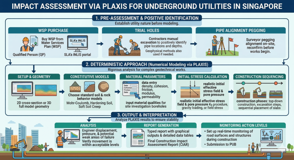
Mastering Geotechnical Impact Assessment via PLAXIS for Underground Utilities in Singapore: A Definitive Guide
Introduction to Subterranean Urbanization and Geotechnical Risk
The relentless expansion of urban infrastructure within geographically constrained city-states requires paradigm-shifting approaches to land use.
Singapore, possessing a land area of merely 734 square kilometers and an exponentially growing population and economy, has strategically pivoted towards the massive exploitation of subterranean space.1
This strategic pivot is formalized in the Urban Redevelopment Authority (URA) Underground Master Plan 2030.
Which meticulously outlines a multi-layered subterranean metropolis designed to accommodate mass rapid transit (MRT) networks, deep tunnel sewerage systems (DTSS), extensive common services tunnels (CST), underground expressways, and specialized utility installations such as the Jurong Rock Caverns and the Bidadari Underground Service Reservoir.1
By migrating essential utility lines—including water, sewage, power grids, and telecommunications—beneath the surface, the state effectively mitigates surface-level negative impacts and frees up high-value real estate for commercial and residential development.1
However, this aggressive subterranean urbanization introduces profound geotechnical complexities for civil and excavating contractors.
The physical act of excavating deep foundation pits, boring tunnels, or driving earth retaining or stabilizing structures (ERSS) fundamentally disrupts the pre-existing, in-situ geostatic stress state of the surrounding soil matrix.4
This stress relief inevitably induces multi-directional ground deformations.
For buried assets, particularly brittle concrete sewers, high-pressure potable water mains, and sensitive telecommunications ducts.
These excavation-induced ground movements can induce intolerable bending moments, shear forces, and angular distortions.6
Consequently, structural failure, leakage, or total loss of serviceability become critical risk vectors that construction companies and construction project management teams must aggressively mitigate.9
To navigate these extreme engineering risks, the execution of a highly rigorous geotechnical impact assessment is a statutory prerequisite for any earthworks in Singapore.5
Finite Element Analysis (FEA), predominantly executed utilizing the PLAXIS 2D and PLAXIS 3D software suites, has established itself as the undisputed industry standard for modeling complex soil-structure interactions.12
PLAXIS provides geotechnical engineers with an arsenal of advanced constitutive material models capable of simulating the highly non-linear, stress-dependent, anisotropic, and time-dependent behavior of geological formations under complex loading and unloading trajectories.12
This exhaustive report dissects the fundamental methodologies, geological parameterization techniques, stringent regulatory compliance frameworks.
Digital ecosystem integrations necessary to perform authoritative impact assessments via PLAXIS for underground utilities in the Republic of Singapore.
The Geotechnical Topography of Singapore: Stratigraphic Complexity
The absolute precision and predictive reliability of any PLAXIS numerical model are inextricably linked to the fidelity of its geological inputs.
The geotechnical landscape underlying Singapore is notoriously heterogeneous, presenting a labyrinth of engineering challenges for deep excavations, pipe-jacking operations, and tunnel boring machine (TBM) alignments.16
The island’s geology is broadly categorized into four primary stratigraphic formations, each exhibiting distinct mechanical behaviors, strength profiles, and hydrogeological characteristics.
The Kallang Formation: The Engineer’s Greatest Challenge
Dominating the coastal perimeters, river valleys, and significant portions of the central-southern commercial districts, the Kallang Formation represents the most formidable challenge to construction engineering in Singapore.16
It is a young Quaternary deposit of marine, alluvial, and estuarine origin.18 Its primary constituent is a highly compressible, practically impermeable, and extremely soft blue-grey marine clay.16
Stratigraphically, the marine clay is frequently encountered as a distinct two-layer structure: the Upper Marine Clay (UMC), which is a Holocene epoch deposit, and the Lower Marine Clay (LMC), a Pleistocene epoch deposit.18
These two exceptionally soft strata are often separated by a stiffer, desiccated intermediate layer of silty clay, reflecting historical periods of sea-level regression and subaerial exposure.18
The engineering properties of the Kallang marine clay are notoriously poor, characterized by very low undrained shear strengths (frequently falling below 30 kPa), exceptionally high moisture contents (ranging from 60% to 80%), and a high compression index.18
When excavating contractors operate within the Kallang Formation, the immediate risks include massive, long-term consolidation settlements, extraordinarily low bearing capacities, and a severe susceptibility to basal heave instability in deep foundation pits.18
Furthermore, the rapid removal of overburden during excavation triggers a significant undrained unloading response, generating negative excess pore water pressures (suction).19
While this suction may provide temporary stability, its eventual dissipation over time leads to profound, delayed ground settlements that can catastrophically damage adjacent underground utilities months or even years after the primary construction works have concluded.
Accurate determination of its depth, thickness, and consolidation parameters necessitates deep boreholes, continuous undisturbed sampling (UDS), and extensive in-situ field vane shear tests (FVT).18
The Old Alluvium
Predominantly underlying the eastern and northeastern sectors of the island, and frequently found forming the bedrock beneath the Kallang Formation, the Old Alluvium is a Pleistocene deposit of fluvial origin.18
It consists primarily of semi-hardened, dense to very dense clayey and silty sands, interspersed with lenses of stiff to hard sandy clays.18
From a geotechnical engineering perspective, the Old Alluvium generally provides an excellent bearing stratum for deep foundations and tunneling operations, often exhibiting Standard Penetration Test (SPT) N-values ranging from 50 to well over 100 blows per 300mm.20
However, its behavior in PLAXIS modeling requires careful attention to its small-strain stiffness and cementation degradation.
While it possesses high initial stiffness, the breakdown of weak inter-particle cementation under high shear strains can lead to brittle failure modes, necessitating advanced constitutive models to capture its non-linear degradation curve accurately.18
The Jurong Formation
Situated beneath the western and southwestern regions of Singapore, the Jurong Formation is a complex sedimentary rock succession comprising alternating layers of mudstone, sandstone, and shale.16
Due to extensive historical tectonic activity, the rock mass is heavily folded, fractured, and steeply dipping.16
The residual soils derived from the profound tropical weathering of the Jurong Formation are highly variable and unpredictable.18
The soil profile can transition abruptly from high-plasticity clays (CH) and low-plasticity clays (CL) to silty sands (SM) over very short horizontal distances.18
This extreme heterogeneity poses severe difficulties for TBM operations, as the machine may simultaneously encounter hard intact rock and soft, cohesive clay at the tunnel face—a scenario known as mixed-face conditions.16
For utility impact assessments, the variable stiffness parameters of the Jurong Formation residual soils mean that differential settlement along the longitudinal axis of a buried pipeline is a high-probability event.21
The Bukit Timah Granite
Covering the central and northwestern core of the island, the Bukit Timah Granite is an igneous formation that transitions from deep residual soils at the surface to completely unweathered, intact granite at depth.16
The residual soil is typically a sandy or silty clay that is often unsaturated above the regional groundwater table.18
The most critical engineering feature of this formation is its highly undulating rockhead.16 The depth to competent rock can vary drastically within a single construction site.
When excavating or tunneling through the transition zone between the residual soil and the intact granite, engineers face severe risks of groundwater ingress, ground loss, and localized instabilities that can immediately propagate to the surface, jeopardizing overlying utilities and infrastructure.16
Advanced Constitutive Modeling in PLAXIS: The Hardening Soil Framework
To execute a reliable geotechnical impact assessment, the selection of the appropriate constitutive soil model within PLAXIS is of paramount importance. The fundamental mechanical behavior of soils and rocks can be modeled at various degrees of sophistication.15
While Hooke’s law of linear, isotropic elasticity provides the simplest mathematical relationship, requiring only Young’s modulus () and Poisson’s ratio (), it is grossly inadequate for capturing the realistic behavior of geomaterials undergoing excavation.15
Similarly, the widely used Mohr-Coulomb (MC) model, representing a linear-elastic perfectly-plastic approximation, is generally insufficient for modeling deep excavations and tunnel boring impacts in Singapore’s complex stratigraphy.15
The MC model assumes a constant stiffness modulus regardless of the stress level and fails to differentiate between the stiffness associated with primary loading and the significantly higher stiffness associated with unloading and reloading.15
In excavation scenarios—which are fundamentally massive unloading events—relying on the MC model will invariably lead to an overestimation of basal heave and an inaccurate prediction of the width and depth of the surface settlement trough, compromising the utility damage assessment.22
Mechanics of the Hardening Soil (HS) Model
To accurately predict ground surface settlement troughs, wall deflections, and the resulting induced stresses on underground utilities, the Hardening Soil (HS) model or the Hardening Soil model with small-strain stiffness (HSsmall) is the strictly recommended standard for PLAXIS 2D and 3D analyses in Singapore.21
The HS model is an advanced, multi-surface plasticity model formulated to capture the macroscopic phenomena of soil behavior, most notably the stress-dependency of soil stiffness and the distinction between primary virgin loading and unloading/reloading.12
Instead of a single Young’s modulus, the HS model requires three distinct input stiffness parameters:
- (Secant Stiffness): The secant stiffness modulus derived from a standard drained triaxial test at 50% of the maximum deviatoric stress.23
- (Tangent Stiffness): The tangent stiffness modulus for primary oedometer loading, reflecting the material’s compressibility under one-dimensional consolidation.23
- (Unloading/Reloading Stiffness): The stiffness modulus governing the elastic response during unloading and reloading cycles, which is critical for excavation modeling.23
The stress-dependency of these stiffness parameters is governed by a power law, utilizing a power parameter () and a reference minor principal stress (), which is almost universally standardized at 100 kPa.22 The secant stiffness modulus at any given minor principal effective stress () is mathematically defined as:
Where is the effective cohesion and is the effective angle of internal friction.22 In PLAXIS, the model also incorporates a dilatancy cut-off mechanism.
Once the volumetric strain reaches a state corresponding to the maximum void ratio, the mobilized dilatancy angle () is automatically reduced to zero, preventing unrealistic infinite volume expansion during shear failure.22
Parameterizing Singapore’s Stratigraphy
Deriving these advanced parameters requires a combination of high-quality laboratory testing (consolidated undrained triaxial tests, continuous oedometer testing) and advanced in-situ correlations (CPTu, Dilatometer tests).23
For the Kallang Formation’s soft marine clays, extensive local geotechnical research and back-analyses of massive deep excavations have established reliable empirical correlations.20 Typically, for the marine clay, the secant stiffness is assumed to be roughly equivalent to the oedometer stiffness , while the unloading-reloading modulus is generally approximated as three times ().25
The power parameter is highly indicative of the soil type. For the highly compressible, soft marine clays, is typically set close to 1.0, reflecting a directly linear relationship between stiffness and effective stress.23
Conversely, for the dense, granular fluvial sands of the Old Alluvium, is typically set at 0.5, representing a square-root dependency typical of sandy soils.23
The following comprehensive table synthesizes typical reference values and Hardening Soil model parameters required for PLAXIS 3D inputs, collated from extensive geotechnical literature, ASCE journals, and major infrastructural SI reports across Singapore 20:
| Stratigraphic Formation / Soil Designation | Drainage Type | Unit Weight γ (kN/m³) | E50ref (MPa) | Eoedref (MPa) | Eurref (MPa) | Power m | c′ (kPa) | φ′ (deg) | K0nc |
| Fill (F) | Drained | 18.0 – 19.0 | 10.0 – 15.0 | 10.0 – 15.0 | 30.0 – 45.0 | 0.50 | 0.25 | 30.0 | 0.50 |
| Estuarine Peat (E) | Undrained | 13.0 – 14.0 | 1.5 – 3.3 | 1.5 – 3.3 | 4.5 – 10.0 | 1.00 | 1.00 | 20.0 | 0.65 |
| Upper Marine Clay (UMC) | Undrained | 15.0 – 16.0 | 2.5 – 5.2 | 2.5 – 5.2 | 7.5 – 15.6 | 0.80 – 1.00 | 1.00 – 5.0 | 22.0 – 24.0 | 0.60 |
| Lower Marine Clay (LMC) | Undrained | 15.5 – 16.5 | 4.0 – 9.1 | 4.0 – 9.1 | 12.0 – 27.3 | 0.80 – 1.00 | 1.00 – 5.0 | 22.0 – 24.0 | 0.55 |
| Fluvial Sand (F1) | Drained | 19.0 – 20.0 | 15.0 – 20.0 | 15.0 – 20.0 | 45.0 – 60.0 | 0.50 | 0.25 | 30.0 | 0.50 |
| Fluvial Clay (F2u/F2L) | Undrained | 18.0 – 19.0 | 13.0 – 15.6 | 13.0 – 15.6 | 39.0 – 46.8 | 0.80 | 5.0 – 10.0 | 26.0 – 28.0 | 0.55 |
| Old Alluvium (N=50) | Drained | 20.0 – 21.0 | 40.0 – 65.0 | 40.0 – 65.0 | 120.0 – 195.0 | 0.50 | 10.0 | 32.0 | 0.45 |
| Old Alluvium (N 100) | Drained | 21.0 – 22.0 | 80.0 – 130.0 | 80.0 – 130.0 | 240.0 – 390.0 | 0.50 | 35.0 | 35.0 | 0.40 |
| Jurong Formation (Stiff Clay) | Undrained | 19.0 – 20.0 | 25.0 – 50.0 | 25.0 – 50.0 | 75.0 – 150.0 | 0.60 – 0.80 | 15.0 – 30.0 | 26.0 – 30.0 | 0.50 |
Data synthesized from geotechnical site investigations and academic back-analyses of Singapore deep excavations.20 Note: The reference stress is universally set at 100 kPa.
The Statutory Regulatory Landscape for Underground Utility Protection
In Singapore, geotechnical impact assessments are not purely academic or internal risk-management exercises; they are strictly governed by unyielding statutory mandates.
The dense interleaving of infrastructure requires absolute regulatory oversight, primarily enforced by three powerful government bodies: the Public Utilities Board (PUB), the Land Transport Authority (LTA), and the Building and Construction Authority (BCA).
Failing to satisfy these agencies’ stringent impact assessment criteria will result in immediate project stop-work orders, immense financial penalties, and potential prosecution under Singaporean law.29
Public Utilities Board (PUB): Safeguarding the Water and Sewerage Nexus
The PUB acts as Singapore’s national water agency, governing the entire hydrological cycle, encompassing the pristine potable water supply network, the expansive public sewerage system, and the island’s comprehensive surface water drainage networks.30
When licensed general contractors or excavating contractors operate within the vicinity of these critical assets, the engineering constraints are absolute.
Under the Public Utilities Act (PUA), Section 47A, any party that willfully or otherwise damages a PUB water main faces severe criminal penalties, including massive fines and imprisonment.29
Therefore, any proposed earthworks, piling, or building works within the defined “protection corridor” of a water pipe must undergo rigorous scrutiny.29
For minor distribution pipes (diameter < 300mm), formal notification and adherence to setback clearances are required.
However, for major transmission mains (diameter 300mm), the Qualified Person (QP) must submit an exhaustive PLAXIS 3D impact assessment and obtain written approval from the PUB Water Supply Network (WSN) department prior to any site mobilization.29
The PUB’s Code of Practice on Sewerage and Sanitary Works (3rd Edition, March 2025) outlines identically strict mandates for the protection of public sewers.31
The “Public Sewer Corridor” is legally defined as the three-dimensional land and space bounded by vertical planes running alongside the sewer.31
Heavy construction activities, including the erection of site offices, stacking of concrete blocks for pile testing, and the operation of heavy machinery, are severely restricted within this corridor to prevent untoward surcharge loads.31
For major underground infrastructure, particularly sewers 900mm in diameter and the critical Deep Tunnel Sewerage System (DTSS), the PLAXIS impact assessment must conclusively demonstrate compliance with the following non-negotiable performance limits 34:
- Vibration Constraints: Peak Particle Velocity (PPV) generated by TBMs, piling rigs, or blasting must not exceed 15 mm/s at any frequency at the sewer interface.34
- Ground Displacement and Structural Integrity: The fundamental objective is zero ground displacement. However, if PLAXIS models predict unavoidable displacement, the subsequent structural analysis of the sewer must prove that the calculated crack width in the concrete lining will not exceed 0.1 mm.34
- Load Transfer: Any additional stress, surcharge, or earth pressure transferred to the sewer structure by adjacent construction works must not exceed an average of 10 kPa.34
- Hydrogeological Stability: Groundwater drawdown resulting from dewatering activities must be meticulously controlled and must not exceed 10 kPa (equivalent to approximately a 1.0-meter drop in the hydraulic head) in the immediate vicinity of the sewers, preventing sudden spikes in effective stress that would trigger rapid consolidation.34
Furthermore, the QP must establish a continuous, real-time instrumentation and monitoring regime—comprising inclinometers, automated ground settlement markers, vibration meters, and piezometers—to dynamically verify that the actual field performance remains within the safe limits established by the PLAXIS predictive models.33
Land Transport Authority (LTA): The Railway Protection Zone
The Land Transport Authority is tasked with protecting the structural integrity and uninterrupted operation of Singapore’s vast Rapid Transit System (RTS).
To achieve this, the LTA enforces the Rapid Transit Systems (Railway Protection, Restricted Activities) Regulations, which establish two critical spatial boundaries: the “Railway Corridor” (defined as the area within 40 meters from the outermost edge of any railway structure) and the broader “Railway Protection Zone”.35
Any development proposal falling within the Railway Protection Zone is subjected to a rigorous, multi-stage submission and approval process.35
- First Stage (Preliminary Engineering Assessment): A Professional Engineer (Civil) must be engaged to conduct a preliminary assessment of the effects of the proposed development on the MRT structures, often requiring initial 2D or simplified 3D FEA modeling.35
- Second Stage (Detailed Design): Comprehensive PLAXIS 3D models must be constructed to simulate the entire construction sequence.
- Third Stage (Construction and Monitoring): Continual validation of the PLAXIS models against live monitoring data.
The LTA Civil Design Criteria dictate the specific load cases and performance thresholds that the impact assessment must satisfy.38
The assessment must account for the pre-existing movements of the bridge or tunnel structures, evaluating the cumulative impact of the new engineering works.38
For deep MRT tunnels, the absolute deformation tolerances are extraordinarily tight.
In many cases, an induced diametrical distortion or deformation of the tunnel lining approaching a mere 6 mm is considered a critical limit state, requiring immediate intervention, redesign, or the implementation of protective advanced works such as ground freezing or underpinning.4
Building and Construction Authority (BCA): Performance-Based ERSS Framework
The Building and Construction Authority (BCA) provides the overarching legal framework for structural safety through the Building Control Act and its subsidiary regulations.11
Under Regulations 31, 32, and 33, any party undertaking building works, demolition, piling, or site formation (including deep excavation) must execute a pre-construction survey and submit a comprehensive “Impact Assessment Report”.11 This report must detail specific recommendations and measures to prevent settlement or ground movement that could impair the stability of any adjacent premises, buildings, or utilities.42
In March 2024, the BCA significantly updated its regulatory approach, issuing a circular that mandated a “Framework on Performance-Based Impact Assessment” for Earth Retaining or Stabilising Structures (ERSS) and tunneling works.5
Historically, many impact assessments relied on a “Deemed-to-Satisfy Approach,” utilizing simplified empirical formulas to estimate ground settlement.
However, when these basic empirical limits cannot be met—a frequent occurrence in Singapore’s dense urban environment—the BCA framework now explicitly requires QPs to execute a comprehensive 3D finite element numerical analysis, termed the “Rigorous Approach”.5
This Rigorous Approach allows engineers to move beyond conservative empirical assumptions. By utilizing PLAXIS 3D, QPs can explicitly model the complex soil-structure interactions, deriving a more accurate, site-specific allowable limit for ground movement and utility deformation.5
The framework ensures that the design is neither overly conservative (which wastes immense financial resources) nor unsafe, promoting highly efficient, data-driven engineering solutions.5
Finite Element Modeling Methodologies for Buried Utilities in PLAXIS
Transitioning from the regulatory requirements to the practical application of finite element analysis, the execution of a PLAXIS assessment requires profound technical expertise.
The historical reliance on 2D plane strain analysis is rapidly becoming obsolete when dealing with the intricacies of urban subterranean infrastructure.43
While PLAXIS 2D remains computationally efficient for preliminary greenfield assessments, infinite-length trench excavations, or perfectly parallel tunneling alignments 44, its fundamental plane strain assumption is fundamentally flawed for localized 3D problems.
It cannot accurately replicate the 3D stress-arching effects around discrete, orthogonally crossing utility pipelines, the localized face pressures of pipe-jacking operations, or the asymmetric geometry of deep shaft excavations.46
PLAXIS 3D is strictly necessary for detailed, stage-by-stage simulations of complex interaction mechanisms, particularly when utilities traverse excavations at skewed angles or when dealing with complex retaining wall geometries like intersecting secant pile walls or corner bracing effects.4
Modeling the Underground Utility: Element Selection
A critical decision defining the accuracy of the PLAXIS 3D model is the selection of the appropriate structural element to represent the existing underground water main, sewer, or gas pipeline.
The choice directly affects both computational time and analytical fidelity.7
- Plate Elements: Plate elements are two-dimensional surface elements deployed within the 3D space, defined by a flexural rigidity () and axial stiffness ().50 They are conceptually suitable for modeling large-diameter, thin-walled structures like flexible steel pipes or box culverts. However, their primary limitation is that they lack physical thickness in the finite element mesh; the soil matrix essentially flows “through” the theoretical volume of the pipe wall, failing to capture the true volumetric displacement of soil caused by the utility’s physical presence.50
- Volume Elements (Solid Mesh): Modeling the utility using full solid volume elements assigned with linear-elastic material properties (e.g., concrete, cast iron, or steel) is the most geometrically and physically rigorous approach.48 It accurately captures the physical geometry, the exact wall thickness, and the volumetric displacement of the pipe within the soil matrix. The major drawback is analytical: extracting internal structural forces (bending moments, normal forces, and shear forces) directly from the stress tensor of volume elements is mathematically complex and often messy. To circumvent this, engineers must superimpose a “dummy” beam element—assigned with negligible weight and stiffness (reduced by a factor of 1000)—along the exact centroidal axis of the volume pipe purely to act as a data-logger for structural forces.49
- Embedded Beam Elements: The embedded beam is a one-dimensional line element that can be placed in any arbitrary orientation within the 3D sub-soil model.50 It interacts with the surrounding soil elements via special line-to-line interface elements, simulating both skin friction and foot resistance.50 Embedded beams are highly advantageous because they permit the direct, frictionless extraction of bending moments, shear forces, and axial loads.48 While traditionally optimized for modeling deep foundation piles, rock bolts, or ground anchors 53, their use for simulating utilities is gaining traction. However, using a 1D line to represent a 2-meter diameter pipe requires careful calibration of the equivalent bounding box and interface parameters to ensure that spatial soil arching is accurately captured.53
The Critical Interface Reduction Factor ()
The physical interaction and stress transfer mechanism between the outer surface of the utility and the surrounding soil matrix is simulated using interface elements.
The strength of this interface is mathematically governed by the strength reduction factor, , which proportionately reduces the soil’s effective cohesion () and effective friction angle () at the immediate contact surface.55
Selecting the correct value is arguably one of the most sensitive parameters in the entire impact assessment.
The magnitude of the bending moments and differential settlements predicted for the pipeline is highly contingent upon this value.57
- Flexible Steel Pipes: Due to the inherently smooth exterior surface of steel pipelines, lower values are adopted, typically ranging between , indicating limited friction mobilization.55
- Rigid Concrete Sewers/Pipes: The rougher surface of concrete mobilizes significantly higher skin friction and mechanical interlocking with the soil, justifying higher values typically ranging between .55
- Excavation Methodology Impact: When simulating adjacent construction activities, such as the installation of secant pile walls near the utility, the construction method dictates the factor. The installation of bored piles significantly disturbs and remolds the surrounding soil matrix, generally requiring a lower compared to driven piles to reflect the loss of intact soil strength.55
A common and highly dangerous pitfall in PLAXIS modeling involves overestimating or in the soft marine clays of the Kallang Formation.57
This overestimation can artificially inflate the calculated passive earth resistance acting against the ERSS walls, leading to an unconservative, unsafe under-prediction of ground deformations and pipe deflections.57
Simulating Construction Sequencing and Hydrogeology
The Staged Construction mode within PLAXIS is the engine that drives the impact assessment, allowing for the precise chronological simulation of the excavation process, capturing the exact history of stress changes upon the rock mass and soil matrix.13
For a robust assessment of impacts on an existing water main, the construction sequence must meticulously model reality:
- Initial Phase (Geostatic Stress Generation): Generation of initial in-situ stresses utilizing the procedure for flat terrain or Gravity Loading for undulating topographies.45
- Utility Initialization: The “wished-in-place” activation of the existing utility pipeline, followed by resetting all displacements to zero to establish the baseline equilibrium condition prior to new construction.44
- ERSS Installation: The activation of the structural elements comprising the retaining system, whether they be diaphragm walls, secant pile walls, or steel sheet piles.45
- Dewatering Operations: Lowering the phreatic surface within the excavation pit. This phase is exceptionally hazardous for utilities embedded in the highly compressible Marine Clay. The sudden drop in pore water pressure triggers an immediate corresponding increase in effective stress, inducing rapid consolidation settlement that acts as a massive downdrag force on the buried pipe.21
- Excavation and Structural Support: The sequential, highly controlled deactivation of soil volume clusters representing the excavated earth, coupled with the simultaneous activation of internal cross-lot struts, walers, or tie-back ground anchors.45
When constrained to PLAXIS 2D, engineers must often rely on the “Convergence-Confinement Method” (CCM) to mathematically approximate the 3D spatial arching effects that occur near an advancing excavation face.
This involves defining specific stress relaxation percentages (e.g., allowing the soil to relax by 40% to 79% before the theoretical installation of the support lining).43
However, transitioning to fully 3D PLAXIS models entirely negates the need for these complex CCM approximations, providing highly accurate, deterministic displacement vectors and bending moments along the entire longitudinal axis of the utility network.44
Digital Convergence: BIM, GIS, and the Digital Underground
The traditional geotechnical workflow is currently undergoing a massive digital revolution. Historically, the process of transitioning from flat, 2D CAD utility layouts to complex 3D finite element meshes was an arduous, highly manual, and deeply error-prone process that often led to the misrepresentation of utility coordinates.62
Today, the convergence of Building Information Modeling (BIM), Geographic Information Systems (GIS), and finite element analysis acts as a strategic multiplier for engineering accuracy.63
The Digital Underground Project
Spearheaded by the Singapore Land Authority (SLA) in deep collaboration with the Singapore-ETH Centre (SEC), the ambitious “Digital Underground” project aims to establish a high-fidelity, highly reliable, nationwide 3D digital twin of all subterranean utilities in Singapore.65
This massive geospatial database utilizes standardized open formats, notably Industry Foundation Classes (IFC) and CityGML.63
By successfully accommodating legacy 2D maps of existing water pipes, complex telecommunication networks, and high-voltage power grids into a single, consolidated 3D repository, urban planners and excavating contractors can effectively eliminate the spatial “blind spots” that have traditionally plagued underground construction.65
The roadmap for this initiative emphasizes data governance, continuous monitoring, and the establishment of a sustainable utility mapping ecosystem using advanced Ground Penetrating Radar (GPR) and laser photogrammetry.65
Seamless BIM-to-PLAXIS Interoperability
Bentley Systems’ strategic acquisition of PLAXIS has fundamentally bridged the historic divide between structural BIM platforms and geotechnical FEA solvers.69
Modern digital workflows now allow for the direct extraction of spatial coordinates and physical attribute information from standardized IFC or GeoJSON formats, automating the generation of intelligent BIM objects directly within the PLAXIS 3D modeling interface.63
Advanced geological modeling tools, such as Leapfrog Works and OpenGround, integrate flawlessly with PLAXIS.
This allows geotechnical engineers to synthesize massive volumes of disparate borehole data, SPT N-values, and laboratory results into continuous, highly accurate 3D stratigraphic models.69
When this 3D ground model is spatially merged with the exact geometric coordinates of the existing utilities derived from the Digital Underground twin, engineers achieve an unparalleled, absolute level of geometric precision in their finite element meshes.66
This interoperability empowers teams to conduct rapid sensitivity analyses, utilize the PLAXIS Tunnel Designer for parametric geometry generation, and perform iterative design optimization at unprecedented speeds.59
As highlighted by the upcoming Digital Construction Asia 2026 summit in Singapore, the utilization of digital twins, cloud platforms, and BIM integration is no longer a futuristic concept but the baseline standard for delivering complex, high-stakes infrastructure projects.72
Landmark Case Studies in Geotechnical Impact Assessment
The theoretical principles, constitutive models, and regulatory constraints surrounding PLAXIS impact assessment are best illuminated through the lens of recent, highly complex mega-infrastructure projects in Singapore.
The Thomson-East Coast Line (TEL) at Marina Bay
The design and construction of the TEL interchange at Marina Bay represents one of the most formidable geotechnical and structural engineering challenges undertaken in recent history.73
The project mandate required the new, massive mainline tunnels to physically undercross the live, fully operational, and highly sensitive passenger tunnels of both the North-South Line (NSL) and the Circle Line (CCL).41
The stratigraphy at Marina Bay was exceptionally hostile, consisting of thick, highly permeable sand layers and ultra-soft marine clays, directly overlying the extremely hard and abrasive Fort Canning Boulder Bed (FCBB).61
To ensure the absolute protection of the live MRT tunnels overhead, an exhaustive PLAXIS 3D impact assessment was executed.41
The numerical models assessed the viability of using a unique, specialized rectangular shield machine to carefully mine access tunnels.41
Furthermore, PLAXIS was utilized to simulate the effects of massive horizontal jet grouting arrays, deployed to create a continuous, 4-meter-thick low-permeability stabilized soil slab directly beneath the existing tunnel bases.41
The analysis also evaluated the implementation of a first-of-its-kind “Trouser Leg” diaphragm wall panel system. The tunnels were supported by massive 2.8m wide barrettes spaced at 12m intervals, deeply socketed into the FCBB, while intermediate, shorter diaphragm wall panels “floated” in the soft marine clays.61
Comparative studies between PLAXIS 2D and PLAXIS 3D Foundation demonstrated that while 2D models could approximate the behavior with simplifying assumptions, the complex 3D load-transfer mechanisms—including the phased removal of existing support piles and the installation of new underpinning transfer beams—required true 3D finite element validation to guarantee that induced ground movements remained securely within the LTA’s draconian millimeter-level operational tolerance limits.41
State-of-the-art ground freezing techniques were also computationally modeled to ensure localized soil stabilization without causing destructive frost-heave damage to the existing structures.41
The Cross Island Line (CRL) Environmental and Utility Protection
Projected to become Singapore’s longest fully underground mass transit artery at over 50 kilometers in length, the Cross Island Line (CRL) dives to extreme depths of up to 70 meters below the surface, tunneling directly beneath the highly sensitive Central Catchment Nature Reserve (CCNR), Turf City, and the Windsor Nature Park.75
The extreme depth of the excavation, combined with the ecological sensitivity of the surface, required high-fidelity PLAXIS modeling to ensure absolute zero impact on both surface habitats and the critical subterranean water transmission networks.76
A critical juncture occurred where the CRL tunnel alignment intersected the immediate vicinity of the Public Utilities Board’s (PUB) vital twin 1800mm diameter potable water transmission pipelines, which link the Bukit Kalang Service Reservoir to Upper Thomson Road.78
Leveraging 3D ground models integrated seamlessly via Leapfrog Works and PLAXIS 3D, engineering teams executed vast sensitivity studies to mathematically predict the precise shape, depth, and volumetric extent of the ground settlement trough generated by the deep TBM drives.70
The use of Leapfrog’s 3D visualization capabilities allowed stakeholders to comprehend complex geological formations, rapidly identifying high-risk zones associated with stability and settlement.70
The digital workflow was so hyper-efficient that structural impact assessments, which traditionally demanded the labor of six geotechnical engineers, were completed by just two, with a reported 90% increase in efficiency over traditional 2D mapping methods.70
The rigorous numerical data verified that the volumetric loss associated with the deep tunnel boring through the Bukit Timah Granite formation would not propagate differential settlements capable of inducing bending failures, longitudinal cracking, or joint separation in the critical high-pressure water mains situated high above the tunnel crown.16
This computational foresight allowed the project team to finalize an optimized alignment design that simultaneously satisfied the LTA’s infrastructural expansion goals and the PUB’s zero-tolerance structural damage thresholds.70
Deep Excavations and Pipe Box Tunnels in the Jurong Formation
Deep foundation pits excavated in the western sectors of Singapore frequently encounter the highly variable, unpredictable residual soils of the Jurong Formation.16
A documented engineering case study involving an open-cut foundation pit adjacent to an existing, active pipeline network clearly demonstrated the sheer necessity of comprehensive 3D numerical evaluation over outdated empirical methods.6
In this scenario, PLAXIS 3D successfully modeled the asymmetric deformation of the ERSS retaining walls and the resultant multi-directional stress relief on the active side of the excavation pit.
The existing pipeline, modeled using rigorous structural elements, was subjected to varying, non-linear degrees of settlement along its longitudinal axis due to the heterogeneous nature of the Jurong soils.7
The PLAXIS analysis successfully identified critical inflection points along the pipe where angular distortion abruptly exceeded the utility’s allowable strain limits.
This early, predictive identification allowed construction project management to proactively implement localized soil improvement techniques (such as deep soil mixing) and mandate the installation of heavy cross-lot bracing prior to reaching the full excavation depth, entirely averting a catastrophic pipeline failure.6
Similarly, studies exploring the excavation within Pipe Box Tunnels (PBT)—such as the Sentosa Gateway PBT project—utilize PLAXIS 3D to understand the complex induced influence zones and the deformation of the surrounding ground, ensuring that internal steel pipes remain structurally secure during the staged removal of earth from the box structure.46
Conclusion
The ongoing, explosive proliferation of subterranean infrastructure in the Republic of Singapore stands as an engineering marvel, born out of absolute geographic necessity and sustained by visionary urban planning.
However, the physical reality of excavating deep foundation pits and driving massive tunnel boring machines adjacent to live, highly sensitive MRT tunnels, vast DTSS sewer networks, and highly pressurized water mains introduces catastrophic risk vectors into the built environment.
The application of Geotechnical Impact Assessment via PLAXIS for underground utilities in Singapore provides the highest possible tier of predictive engineering assurance.
By moving decisively beyond simplified, historically conservative 2D empirical assumptions and leveraging the full, unbridled computational power of PLAXIS 3D, geotechnical engineers can accurately, mathematically simulate the immensely complex spatial soil-structure interactions inherent in deep urban excavations.
Utilizing highly advanced constitutive frameworks, most notably the Hardening Soil model, allows for the precise, mathematically rigorous replication of the stress-dependent, non-linear, and elastoplastic behavior of Singapore’s challenging stratigraphies—from the ultra-soft, highly compressible marine clays of the Kallang Formation to the dense, cemented fluvial sands of the Old Alluvium.
Furthermore, the seamless integration of these high-fidelity finite element models with the nation’s rapidly evolving Digital Underground twin, massive GIS databases, and advanced BIM platforms represents a transformative leap forward in infrastructure planning and risk mitigation.
It enables rapid, data-driven decision-making, ensuring that the strict, unforgiving regulatory thresholds mandated by the Land Transport Authority (LTA), the Public Utilities Board (PUB), and the Building and Construction Authority (BCA) are achieved both efficiently and with the highest margins of safety.
As Singapore aggressively pushes the boundaries of its underground frontier towards the goals of the 2030 Master Plan and beyond, mastering these advanced computational modeling methodologies is no longer a theoretical exercise or an optional luxury.
It is the fundamental, non-negotiable prerequisite for ensuring resilient, safe, and sustainable urban development.
Works cited
- An Underground of Possibilities | URA Master Plan, accessed March 18, 2026, https://www.uradraftmasterplan.gov.sg/themes/strengthening-urban-resilience/an-underground-of-possibilities/
- Uncovering the Underground, accessed March 18, 2026, https://isomer-user-content.by.gov.sg/53/51e5818a-3ce9-434f-abf8-a4814639d17f/clc-lecture-uncovering-the-underground.pdf
- Developing Underground Space: A View From Singapore – WSP, accessed March 18, 2026, https://www.wsp.com/en-us/insights/developing-underground-space-a-view-from-singapore
- Numerical investigation on impact of excavations in influence zone …, accessed March 18, 2026, https://www.researchgate.net/publication/371729626_Numerical_investigation_on_impact_of_excavations_in_influence_zone_of_existing_MRT_tunnels
- 1 Dear Sir/Madam FRAMEWORK ON PERFORMANCE BASED IMPACT ASSESSMENT ASSOCIATED WITH EARTH RETAINING OR STABILISING STRUCTURES (“ – Building and Construction Authority, accessed March 18, 2026, https://www1.bca.gov.sg/docs/default-source/docs-corp-regulatory/building-control/circular—building-assessment–20240306.pdf?sfvrsn=1f1af505_0
- Deformation analysis and safety assessment of existing metro tunnels affected by excavation of a foundation pit – ResearchGate, accessed March 18, 2026, https://www.researchgate.net/publication/342635613_Deformation_analysis_and_safety_assessment_of_existing_metro_tunnels_affected_by_excavation_of_a_foundation_pit
- A Simplified Mechanical Model and Analysis for the Settlement Deformation of Buried Pipelines Caused by Open-Cut Excavation – MDPI, accessed March 18, 2026, https://www.mdpi.com/2076-3417/13/18/10356
- Engineering Mechanics NUMERICAL MODELING OF BURIED SEWER PIPELINE USING PLAXIS SOFTWARE, accessed March 18, 2026, https://engineeringmechanics.az/uploads/2024/03/11-tural-2-5-merged-1.pdf
- (PDF) A Simplified Mechanical Model and Analysis for the Settlement Deformation of Buried Pipelines Caused by Open-Cut Excavation – ResearchGate, accessed March 18, 2026, https://www.researchgate.net/publication/373998415_A_Simplified_Mechanical_Model_and_Analysis_for_the_Settlement_Deformation_of_Buried_Pipelines_Caused_by_Open-Cut_Excavation
- Free SEO Keyword Research – 50 Most Popular Keywords for Construction Companies & Where to Use Them – Digital Success Blog, accessed March 18, 2026, https://www.digitalsuccess.us/blog/free-seo-keyword-research-50-most-popular-keywords-for-construction-companies-where-to-use-them.html
- No. S 666 BUILDING CONTROL ACT (CHAPTER 29) BUILDING CONTROL REGULATIONS 2003, accessed March 18, 2026, https://sso.agc.gov.sg/SL/BCA1989-S666-2003?DocDate=20241223&ValidDate=20171215&ViewType=Pdf&_=20250123184641
- Speed, ease and accuracy: Geotechnical tunnel modelling with PLAXIS, accessed March 18, 2026, https://www.bentley.com/wp-content/uploads/plaxis-tunneling-ebook.pdf
- PLAXIS 3D: Geotechnical Engineering Software – Bentley Systems, accessed March 18, 2026, https://www.bentley.com/software/plaxis-3d/
- Best Geotechnical Engineering Software Tools for 2026 – DartisTech, accessed March 18, 2026, https://dartistech.com/best-geotechnical-engineering-software-tools-for-2025/
- PLAXIS 3D 2025.1 Materials Models Manual – Seequent, accessed March 18, 2026, https://files.seequent.com/PLAXIS/Manuals/PLAXIS_3D/English/PLAXIS_3D_3_Material%20Models%20Manual.pdf
- Singapore Soil Formations | PDF | Clay – Scribd, accessed March 18, 2026, https://www.scribd.com/document/413447866/Singapore-Soil-Formations
- Geology and Its Impact on the Construction of Singapore MRT Circle Line – Academia.edu, accessed March 18, 2026, https://www.academia.edu/36547339/Geology_and_Its_Impact_on_the_Construction_of_Singapore_MRT_Circle_Line
- Geotechnical Site Investigation in Singapore: – Stellar Structures, accessed March 18, 2026, https://structures.com.sg/geotechnical-site-investigation-in-singapore/
- Deep excavations in singapore marine clay – INTERNATIONAL SOCIETY FOR SOIL MECHANICS AND GEOTECHNICAL ENGINEERING, accessed March 18, 2026, https://www.issmge.org/uploads/publications/6/11/2005_002.pdf
- MODELLING GROUND RESPONSE FOR DEEP EXCAVATION IN SOFT GROUND – GEOMATE Journal, accessed March 18, 2026, https://geomatejournal.com/geomate/article/download/2655/2238/3213
- FIELD MEASUREMENTS AND NUMERICAL ANALYSIS OF INTERACTION BETWEEN CLOSELY SPACED BORED TUNNELS – DR-NTU, accessed March 18, 2026, https://dr.ntu.edu.sg/server/api/core/bitstreams/0172f53b-d01c-4180-a835-22601803dc0a/content
- Modelling ground response for deep excavation in soft ground Author Published Journal Title Version Rights statement Downloaded – Research Repository, accessed March 18, 2026, https://research-repository.griffith.edu.au/bitstreams/2c083bf9-2026-4b4b-8654-c09d3538ab82/download
- Soil Parameters of Kallang Formation and Old Alluvium in Singapore for Excavation Study with Plaxis | Practice Periodical on Structural Design and Construction | Vol 27, No 2 – ASCE Library, accessed March 18, 2026, https://ascelibrary.org/doi/10.1061/%28ASCE%29SC.1943-5576.0000665
- Soil Parameters of Kallang Formation and Old Alluvium in Singapore for Excavation Study with Plaxis | Request PDF – ResearchGate, accessed March 18, 2026, https://www.researchgate.net/publication/360301930_Soil_Parameters_of_Kallang_Formation_and_Old_Alluvium_in_Singapore_for_Excavation_Study_with_Plaxis
- Hardening Soil Model Parameters Overview | PDF | Young’s Modulus – Scribd, accessed March 18, 2026, https://www.scribd.com/document/325625951/Hardening-Soil-model-GTSNX
- GeoStudio | PLAXIS Forum – Deriving parameters for soil hardening model – Communities, accessed March 18, 2026, https://bentleysystems.service-now.com/community?id=community_question&sys_id=7216113e47d94a909091861f536d4360
- THE HARDENING SOIL MODEL – A PRACTICAL GUIDEBOOK – ZSoil, accessed March 18, 2026, http://www.zsoil.com/zsoil_manual_2018/Rep-HS-model.pdf
- Numerical modeling of diaphragm wall behavior in Bangkok soil using hardening soil model – INTERNATIONAL SOCIETY FOR SOIL MECHANICS AND GEOTECHNICAL ENGINEERING, accessed March 18, 2026, https://www.issmge.org/uploads/publications/6/13/2011_087.pdf
- Qualified Persons/ Contractors PUB (WSN)/ PUB (CWD) ADVISORY NOTE- PREVENTION OF DAMAGE TO WATER PIPES – PUB, Singapore’s National Water Agency, accessed March 18, 2026, https://www.pub.gov.sg/-/media/PUB/PDF/WSN/PUB-WSN–CWD-Advisory-Prevention-of-Damage-to-Watermains-Aug-2025.pdf
- Guide on Construction of Industrial Developments in Singapore, accessed March 18, 2026, https://www1.bca.gov.sg/docs/default-source/docs-corp-news-and-publications/publications/for-industry/guide_on_construction_of_industrial_developments_in_singapore.pdf
- CODE OF PRACTICE ON SEWERAGE AND SANITARY WORKS (3rd EDITION – MAR 2025) – PUB, Singapore’s National Water Agency, accessed March 18, 2026, https://www.pub.gov.sg/-/media/PUB/PDF/Code-of-Practice-on-Sewerage-and-Sanitary-Works-3rd-Edition–Mar-2025.pdf
- EN – Annex-A – PUB Water Supply System Requirements-20180326 | PDF | Water Supply Network | Pipe (Fluid Conveyance) – Scribd, accessed March 18, 2026, https://www.scribd.com/document/587815737/EN-Annex-A-PUB-water-supply-system-requirements-20180326
- Developers/ Qualified Persons/ Contractors PUB (WSN)/ PUB (CWD) ADVISORY NOTE- PREVENTION OF DAMAGE TO WATER PIPES – PUB, Singapore’s National Water Agency, accessed March 18, 2026, https://www.pub.gov.sg/-/media/Images/Feature/Content-Pages/Professionals/Compliance/Applications/Watermains_AdvisoryNotes.pdf
- CODE OF PRACTICE SEWERAGE AND SANITARY WORKS (2nd EDITION – JAN 2019) (INCLUDED AMENDMENTS UNDER ADDENDUM NO.1 – MAR 2021) – PUB, Singapore’s National Water Agency, accessed March 18, 2026, https://www.pub.gov.sg/-/media/PUB/PDF/Compliance/Used-Water/GreaseTrap/COPSSW2nded2019.pdf
- Code_of_Practice_for_Railway_… – Land Transport Authority (LTA), accessed March 18, 2026, https://www.lta.gov.sg/content/dam/ltagov/industry_innovations/industry_matters/development_construction_resources/Building_Works_Restricted_Activities_in_Railway_Protection_Zone/Codes_of_Practice_Standards_Specifications_Guides_Forms/Code_of_Practice_for_Railway_Protection.pdf
- Rapid Transit Systems (Development and Building Works in Railway Corridor and Railway Protection Zone) Regulations 2021 – Singapore Statutes Online – Attorney-General’s Chambers, accessed March 18, 2026, https://sso.agc.gov.sg/SL/RTSA1995-S712-2021?DocDate=20230531&TransactionDate=20240419235959
- LTA Railway Protection Code of Practice | PDF | Rapid Transit | Surveying – Scribd, accessed March 18, 2026, https://www.scribd.com/document/825521469/Code-of-Practice-for-Railway-Protection-2024-Edition
- Guide to Carrying Out Engineering Works within Road Structure Safety Zone and Engineering Activity on Land adjoining Public Streets – Land Transport Authority (LTA), accessed March 18, 2026, https://www.lta.gov.sg/content/dam/ltagov/industry_innovations/industry_matters/development_construction_resources/Building_Works_Restricted_Activities_in_Railway_Protection_Zone/Codes_of_Practice_Standards_Specifications_Guides_Forms/Road_Structure_Safety_Zone_Guide.pdf
- LTA Civil Design Criteria 2024 | PDF | Track (Rail Transport) | Tunnel – Scribd, accessed March 18, 2026, https://www.scribd.com/doc/178365596/LTA-Civil-standards-Civil-Design-Criteria
- LTA Civil Design Criteria | PDF | Tunnel | Geotechnical Engineering – Scribd, accessed March 18, 2026, https://www.scribd.com/document/157186474/LTA-Civil-Design-Criteria
- MRT Tunnel Construction Insights | PDF | Deep Foundation – Scribd, accessed March 18, 2026, https://www.scribd.com/document/517649765/Design-and-Construction-of-Underground-Mr-t-Structures-Under-Neat
- Building Control Regulations, accessed March 18, 2026, https://www.bca.gov.sg/Publications/BuildingControlAct/others/Compiled_BCRegs15Feb08.pdf
- Tunnel Excavation in Rock with PLAXIS 2D Considering 3D Effects – YouTube, accessed March 18, 2026, https://www.youtube.com/watch?v=OxTubLhuv6s
- Evaluation of Damage to Existing Buildings Induced by Tunnel Excavation – MDPI, accessed March 18, 2026, https://www.mdpi.com/2412-3811/10/1/13
- PLAXIS 2D – Traditional Tunnelling Method: Application of MTM – Bentley Blog, accessed March 18, 2026, https://blog.bentley.com/software/plaxis-2d-traditional-tunnelling-method-application-of-mtm/
- Three-dimensional finite element analysis of a pipe box tunnel in sedimentary rock – INTERNATIONAL SOCIETY FOR SOIL MECHANICS AND GEOTECHNICAL ENGINEERING, accessed March 18, 2026, https://www.issmge.org/uploads/publications/1/120/ICSMGE_2022-48.pdf
- PLAXIS 3D – Traditional Tunnelling Method: Application of MTM – Bentley Blog, accessed March 18, 2026, https://blog.bentley.com/software/plaxis-3d-traditional-tunnelling-method-application-of-mtm/
- How to model pile as volume element in plaxis 3D 2017? which one is better as compared to Embedded beam element? | ResearchGate, accessed March 18, 2026, https://www.researchgate.net/post/How-to-model-pile-as-volume-element-in-plaxis-3D-2017-which-one-is-better-as-compared-to-Embedded-beam-element
- GeoStudio | PLAXIS Forum – Embedded beams vs Volume piles – Communities, accessed March 18, 2026, https://bentleysystems.service-now.com/community?id=community_question&sys_id=c67ca9b21b5d8e90f3fc5287624bcb07
- Embedded Pile Row in Plaxis 2D – Bouassida Geotechnics, accessed March 18, 2026, https://bouassidageotechnics.wordpress.com/wp-content/uploads/2016/05/embedded-pile-row-plaxis.pdf
- PLAXIS Forum – Fixed connection between embedded beam and plate – Communities, accessed March 18, 2026, https://bentleysystems.service-now.com/community?id=community_question&sys_id=f437ceb397d0569436d5f33ef053af02
- How to do pile analysis as volume element in Plaxis 3D – YouTube, accessed March 18, 2026, https://www.youtube.com/watch?v=S_NoiSj6JQo
- PLAXIS Forum – Difference between types of embedded beam row – Communities, accessed March 18, 2026, https://bentleysystems.service-now.com/community?id=community_question&sys_id=6c515e321b91ce90f3fc5287624bcb24
- Validation of PLAXIS Embedded Piles For Lateral Loading – SciSpace, accessed March 18, 2026, https://scispace.com/pdf/validation-of-plaxis-embedded-piles-for-lateral-loading-2unn12t5zq.pdf
- PLAXIS – Frequently Asked Questions – Interface elements – Communities – Sign In, accessed March 18, 2026, https://bentleysystems.service-now.com/community?id=kb_article_view&sysparm_article=KB0047965
- Plaxis 2D – R inter value from CPT test : r/Geotech – Reddit, accessed March 18, 2026, https://www.reddit.com/r/Geotech/comments/1n7jt6s/plaxis_2d_r_inter_value_from_cpt_test/
- Common Mistakes on the Application of Plaxis 2D in Analyzing Excavation Problems – ResearchGate, accessed March 18, 2026, https://www.researchgate.net/profile/Tjie-Liong-Gouw-Dr/publication/282997310_Common_Mistakes_on_the_Application_of_Plaxis_2D_in_Analyzing_Excavation_Problems/links/5625c6af08aed3d3f13719d7/Common-Mistakes-on-the-Application-of-Plaxis-2D-in-Analyzing-Excavation-Problems.pdf
- PLAXIS – 2D Analysis of a Braced Excavation Over an Existing Tunnel – Communities, accessed March 18, 2026, https://bentleysystems.service-now.com/community?id=kb_article_view&sysparm_article=KB0045686
- Rock Your Underground Construction With PLAXIS Sponsored – Geoengineer.org, accessed March 18, 2026, https://www.geoengineer.org/news/rock-your-underground-construction-with-plaxis
- PLAXIS 3D 2025.1 Tutorial Manual – Seequent, accessed March 18, 2026, https://files.seequent.com/PLAXIS/Manuals/PLAXIS_3D/English/PLAXIS_3D_1_Tutorial%20Manual.pdf
- international society for soil mechanics and geotechnical engineering – Paper Template ANZ 2012, accessed March 18, 2026, https://www.issmge.org/uploads/publications/89/82/3_2_1.pdf
- Building Information Modelling for Application in Geotechnical Engineering – MDPI, accessed March 18, 2026, https://www.mdpi.com/2412-3811/8/6/103
- Design and Validation of an Integrated CAD-to-5D BIM Process for Underground Utilities, accessed March 18, 2026, https://www.mdpi.com/2075-5309/15/22/4139
- GIS-BIM Convergence: Transforming Large-Scale Infrastructure & Urban Planning in 2026, accessed March 18, 2026, https://www.teslaoutsourcingservices.com/blog/gis-bim-convergence-how-it-will-transform-large-scale-infrastructure-projects/
- Digital Underground – Singapore-ETH Centre, accessed March 18, 2026, https://sec.ethz.ch/research/digital-underground.html
- Singapore Goes Underground With The Digital Underground Project – Geospatial World, accessed March 18, 2026, https://geospatialworld.net/prime/case-study/aec/singapore-goes-underground-with-the-digital-underground-project-2/
- Towards an Ecosystem of Underground Utilities Mapping in Singapore | GIM International, accessed March 18, 2026, https://www.gim-international.com/content/news/towards-an-ecosystem-of-underground-utilities-mapping-in-singapore?output=pdf
- Singapore is making a 3-D map of its subterranean spaces – Smart Cities Dive, accessed March 18, 2026, https://www.smartcitiesdive.com/news/singapore-is-making-a-3-d-map-of-its-subterranean-spaces/516812/
- Bentley Systems Acquires Plaxis and Soilvision to Enrich Digital Workflows, accessed March 18, 2026, https://www.gim-international.com/content/news/bentley-systems-acquires-plaxis-to-enrich-digital-workflows
- Singapore’s Cross Island Line: navigating depths and diplomacy – Civil – Seequent, accessed March 18, 2026, https://www.seequent.com/singapores-cross-island-line-navigating-depths-and-diplomacy/
- INTUITIVE DIGITAL WORKFLOWS FOR ENHANCED COLLABORATION, accessed March 18, 2026, https://venturisit.de/wp-content/uploads/2022/06/eBook_Geotechnical_Engineering_EN-1.pdf
- Digital Construction Asia 2026 | 31 March to 1 April 2026 – Ibis Singapore on Bencoolen, accessed March 18, 2026, https://www.ibissingaporebencoolen.com/business-travel-2/digital-construction-asia-2026/
- Case Studies of Recent Civil/Geotechnical Highlights in Asia – Singapore Thomson East-coast Line… – YouTube, accessed March 18, 2026, https://www.youtube.com/watch?v=bPusR24WgT0
- Design and Construction of Underground MRT Structures underneath Marina Bay Station, CCL and NSL Tunnels, Singapore – ResearchGate, accessed March 18, 2026, https://www.researchgate.net/publication/309242199_Design_and_Construction_of_Underground_MRT_Structures_underneath_Marina_Bay_Station_CCL_and_NSL_Tunnels_Singapore
- Cross Island Line (CRL) Phase 2 Environmental Impact Study (EIS) – Turf City and Holland Plain – Land Transport Authority (LTA), accessed March 18, 2026, https://www.lta.gov.sg/content/dam/ltagov/who_we_are/statistics_and_publications/report/pdf/2-CR2005_EIS(TurfCity_and_HollandPlain)_NTS.pdf
- Non-Technical Summary – Land Transport Authority (LTA), accessed March 18, 2026, https://www.lta.gov.sg/content/dam/ltagov/who_we_are/statistics_and_publications/report/pdf/Final_SI_EIA_Executive_Summary.pdf
- Cross Island Line (CRL) Phase 2 Environmental Impact Study (EIS) – Windsor & Eng Neo Avenue Forest, accessed March 18, 2026, https://www.lta.gov.sg/content/dam/ltagov/who_we_are/statistics_and_publications/report/pdf/1-CR2005_EIS(Windsor_and_Eng%20Neo)_NTS.pdf
Environmental Impact Assessment for Proposed Water Pipelines from Bukit Kalang to Upper Thomson Road – PUB, Singapore’s National Water Agency, accessed March 18, 2026, https://www.pub.gov.sg/-/media/PUB/PDF/02BKSR_EIA.pdf