




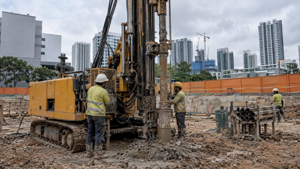
A geotechnical submission in Singapore is the set of plans, calculations and reports that demonstrate to the Building and Construction Authority (BCA) that excavation, earth-retaining, slope, tunnel or foundation works have been designed on a sound ground model and will be supervised on site. It is prepared by the appointed Qualified Person and geotechnical specialists, lodged through the CORENET X gateway process, and followed through construction to completion. This guide explains which works trigger it, which route applies, what the package contains, who signs it, and where submissions most often stall.
TL;DR
- Geotechnical plans are required for tunnels over 2 metres, and for earth-retaining structures and slopes over 6 metres in specified works, under the Building Control Regulations 2003.
- Projects follow the CORENET X Design, optional Piling and Construction Gateways; simpler projects may use the Direct Submission Process.
- From 1 March 2026, site investigation reports must carry certification by an appropriate Professional Engineer, and the data must follow the AGS(SG) format.
- Approval is not the end: the builder remains responsible for earth-retaining structures during the whole construction period, and completion requires as-built records and supervision certificates.
- Most delays come from a weak ground model, an uncertified investigation report or a late appointment of specialists, all of which are avoidable at the planning stage.
Table of Contents
- Which works require a geotechnical submission
- Which approval route applies
- Who must be appointed: QP, PE(Geo) and AC(Geo)
- Documents in a geotechnical submission
- From design to completion
- Obligations that continue after approval
- Common errors and how to avoid them
- Our perspective
- How Stellar Structures supports geotechnical submissions
- FAQ
- Sources
Which works require a geotechnical submission
The starting point is the Building Control Regulations 2003. The Regulations set out the geotechnical plans that accompany an application for structural works, and they identify the height and size thresholds that matter: tunnels over 2 metres, earth-retaining structures in specified works over 6 metres, and slopes constructed or stabilised over 6 metres.
In practice, the following scopes usually bring a geotechnical component into a submission:
- Basement excavations and deep trenches that need temporary earth retaining and stabilising structures (ERSS).
- Permanent retaining walls and cut or fill slopes, including slopes stabilised by soil nailing or ground anchors.
- Deep foundations such as piles, pile caps and deep rafts, particularly on reclaimed land or soft marine clay.
- Tunnels and underground structures above the threshold diameter.
- Landed-home rebuilds and additions and alterations (A&A) that involve new basements, deepened foundations or excavation close to boundaries.
Thresholds are only a first filter. A shallow excavation beside an existing structure, a slope on a sloping landed plot or works next to a road reserve can carry greater ground risk than a deeper excavation on an open site. Height-based rules of thumb are treated cautiously in other jurisdictions too, as retaining wall design guidance shows when it explains why a single fixed height is not a safe rule. For Singapore, the Qualified Person should confirm the trigger against the current regulations at the start of the project, not at the point of lodgement.
Readers comparing the two disciplines can find the division of responsibilities in our note on structural versus geotechnical engineering.
Which approval route applies
Submissions are now made through CORENET X. Projects may use the Design, optional Piling and Construction Gateways, while simpler projects may use the Direct Submission Process. The route is determined by the scope and scale of the project, so it is settled during the planning of the submission and not after the design is finished.
| Stage | What is typically addressed | Geotechnical relevance |
|---|---|---|
| Design Gateway | Design intent, structural and geotechnical design basis, calculations and models | Ground model, design parameters, ERSS and foundation concepts |
| Piling Gateway (optional) | Early piling works ahead of the full construction package | Pile design, load tests, and effects on neighbouring structures |
| Construction Gateway | Construction-stage information before and during works | Temporary works, monitoring plans and supervision arrangements |
| Completion Gateway | As-built records and certificates | As-built models, drawings, supervision certificates |
The table summarizes the gateway structure; the content of each package is defined in BCA’s published requirements. Projects of larger floor area face additional coordination requirements, which we cover in our article on the 5,000 sqm threshold and CORENET X delays. For the wider picture of how BCA and URA submissions differ, see BCA submission versus URA submission.
Who must be appointed: QP, PE(Geo) and AC(Geo)
The Qualified Person (QP) remains the coordinating professional for the structural submission. Where the works are classed as geotechnical building works, the design is typically handled by a Professional Engineer with geotechnical specialisation, PE(Geo), and independently reviewed by an Accredited Checker with geotechnical accreditation, AC(Geo). BCA publishes its requirements for PE(Geo) and AC(Geo) in the guidelines for structural plan applications, alongside its guidance on the observational method for ERSS and groundwater control in deep excavations.
Three practical points follow from this arrangement:
- Appoint early. The ground model, the ERSS concept and the site investigation scope depend on each other. A specialist engaged after the architectural layout is fixed often forces redesign of basement levels or boundary setbacks.
- Separate design from checking. The checker must be independent of the design team, so the appointment must be planned and not arranged at the last stage before lodgement.
- Confirm the current rules. Appointment categories and thresholds are revised from time to time. Verify the present requirements on the BCA page before finalising the project team.
Our civil and structural design checks article explains how independent review fits into a design programme.
Documents in a geotechnical submission
The package varies with the scope, but the core elements are consistent.
Site investigation report
The site investigation (SI) report underpins every other document. Eurocode 7 makes the designer responsible for planning geotechnical investigations, and the GeoSS guide referenced by BCA provides the detail. Two changes deserve attention. From 1 March 2026, SI reports must include certification by an appropriate Professional Engineer verifying the accuracy of the information, and SI data must be provided in the AGS(SG) format. The same guidelines recommend a desk study as the first investigation step, using Singapore Geological Maps and public INLIS borehole data to plan the fieldwork.

The design QP’s duty to carry out site investigation proportionate to the risk has also been reiterated in a 2023 reminder to design Qualified Persons, which describes a robust ground model, tested throughout investigation and construction, as critical for identifying geotechnical uncertainty and deciding whether further testing or monitoring is needed.
For a section-by-section view, see our soil investigation report checklist, and for planning the fieldwork see how to plan the field and laboratory program.
Design calculations, models and drawings
Under CORENET X, structural submission packages include design calculation reports, IFC-SG models, impact assessment reports and topography. For geotechnical works, this normally translates into:
- ERSS and foundation design calculations, with the design parameters traced back to the SI report.
- Drawings of the retaining system, strutting or anchoring, excavation sequence and dewatering where applicable.
- An assessment of the effects of excavation or piling on adjacent buildings, roads and utilities.
- A monitoring plan with instrument layout, trigger levels and response actions.
- Supervision arrangements, naming who inspects the works and how often.
The interpretation of design parameters is often where reviewers raise queries; our guide on reading key findings and design parameters explains the typical points.
From design to completion
The sequence below describes a typical project. Individual projects may differ.
- Scoping. Confirm whether the works are geotechnical building works, identify neighbouring structures and services, and decide the gateway route.
- Desk study and site investigation. Review geological maps and borehole records, then plan boreholes, in-situ tests and laboratory tests to match the ground variability.
- Ground model and design. Establish characteristic values, select the retaining or foundation system and prepare the calculations and drawings.
- Independent check. The accredited checker reviews the design and the QP resolves comments.
- Lodgement and response. Submit through the relevant gateway and respond to authority queries.
- Construction. Install the temporary and permanent works under supervision, with monitoring against agreed trigger levels.
- Completion. The Completion Gateway package includes as-built IFC-SG models, 2D drawings, design calculations, supervision certificates and relevant forms.
For general guidance on keeping a plan application moving, see how to submit BCA plans without delays.
Obligations that continue after approval
Approval does not transfer the ground risk away from the project. Regulation 36 of the Building Control Regulations requires the builder to provide and maintain earth-retaining structures for all foundations and excavations, so that adjoining properties are not damaged or moved during the construction period. Owners and developers should therefore confirm that the contractor’s temporary works programme, monitoring readings and inspection records match what was submitted.
Typical follow-up items include:
- Regular review of monitoring data against trigger levels, with a documented response when a level is reached.
- Supervision records signed by the appointed supervising professionals.
- Submission of revised calculations where ground conditions encountered differ from the design assumptions.
- As-built information and certificates at completion.
Where ground conditions turn out to be poor, ground treatment may be needed; our note on soil improvement for Singapore’s challenging ground outlines the available approaches.
Common errors and how to avoid them
| Issue | Consequence | Preventive check |
|---|---|---|
| SI report without Professional Engineer certification | Report is not accepted for the submission | Confirm certification and AGS(SG) data format before the design starts |
| Too few boreholes for variable ground | Design parameters are challenged and additional investigation is required | Match the borehole spacing and depth to the ground variability and the structure |
| Desk study skipped | Known geological features, such as soft clay pockets or old fill, are discovered late | Review geological maps and public borehole records first |
| Specialists appointed late | Redesign of basement depth or retaining system | Appoint the PE(Geo) and checker at concept stage |
| Monitoring plan without trigger levels | Authority comments and weak construction control | Define alert and action levels with response measures |
| Neighbouring structures not assessed | Impact assessment queries, delay in approval | Complete a pre-construction survey and impact assessment early |
Because a ground model is only as reliable as the data behind it, uncertainty should be handled openly in the submission. Where the data are thin, the sound approach is more investigation or construction-stage monitoring, and not a confident parameter without evidence. Property buyers elsewhere use spatial property risk assessment to flag hidden risks before commitment, and the same logic applies to ground risk on a development site: identify the unknowns before the design relies on them. Our list of common errors and red flags in submitted SI reports gives further detail.
Our perspective
We see geotechnical submissions fail less often on calculation quality than on sequence. The investigation is commissioned after the architecture is settled, the specialist joins after the basement depth is fixed, and the authority comments arrive when the programme has no room for them. A submission is quickest when the ground model is treated as a design input from the first week, when the checker is known early, and when the contractor’s temporary works are reviewed against the same assumptions that were submitted.
We also hold that the owner should understand the ground risk in plain terms. A geotechnical report that cannot be explained to the person funding the project has not finished its job. Our practice is to set out what is known, what is assumed and what will be monitored, so that decisions about further investigation or ground treatment are made with the cost and the risk in view.
— Aman
How Stellar Structures supports geotechnical submissions
Stellar Structures is a Singapore design and engineering firm that provides structural and geotechnical engineering consultation, civil and structural design checks and authority submissions to BCA, URA, HDB, JTC, SCDF, PUB, LTA, NEA and NParks. Property owners, developers, contractors and architects engage us for the coordination of the structural and geotechnical package, so that the investigation, the design and the authority route are aligned from the start. Details of each service are on our services page.
Fees are agreed per project engagement and are not published; the scope of works is confirmed after we review the site and the intended development.
FAQ
Is a geotechnical submission required for every landed home rebuild?
Not automatically. The requirement depends on the works: deep basements, tall retaining walls or slopes above the regulatory thresholds bring in geotechnical plans, while a conventional rebuild on level ground may need only a structural submission. The appointed QP should confirm the position against the Building Control Regulations before design begins.
Who prepares the site investigation report?
A specialist investigation contractor carries out the fieldwork, and the report is prepared and certified under the responsibility of a Professional Engineer. From 1 March 2026, BCA’s guidelines require that certification and the AGS(SG) data format. The design QP remains responsible for ensuring the investigation is adequate for the design.
Can the submission be lodged before the soil investigation is complete?
The design should not rely on parameters that have not been established. In practice, the design package needs the investigation results to justify the retaining or foundation design, so the investigation is scheduled ahead of the Design Gateway submission.
Does approval end the geotechnical responsibilities?
No. The builder must maintain earth-retaining structures throughout construction under Regulation 36, monitoring continues against the agreed levels, and the Completion Gateway requires as-built records and supervision certificates.
Sources
- Building Control Regulations 2003, Singapore Statutes Online
- CORENET X: 3-gateway process
- BCA guidelines on requirements for site investigation reports
- CORENET X structural submission and IFC-SG requirements
- BCA guidelines for ST plan applications
- Reminder for design Qualified Persons to carry out site investigation, 20 September 2023
Recommended
- Geotechnical Site Investigation in Singapore:
- Soil Investigation Report Preparation: Singapore Guide