




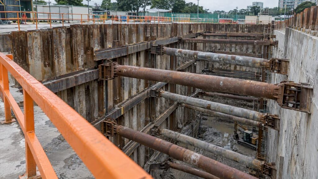
An earth retaining and stabilising structure (ERSS) is any structure or structural system that maintains the shape of an excavation during construction. In Singapore, its design starts with adequate site investigation and Eurocode 7 limit-state checks. The design is then carried through a Qualified Person (QP) submission to BCA and tested by monitoring during excavation. This article sets out the fundamentals in the order a project team meets them: what counts as ERSS, how systems are selected, which checks govern, which documents are needed and what must be monitored on site.
TL;DR
- ERSS covers walls, struts, anchors, berms and related elements that hold an excavation open. The submission route depends on depth: up to 4 m, from 4 m to 6 m, and above 6 m.
- Design follows SS EN 1997-1 (Eurocode 7) with Singapore’s National Annex. Equilibrium (EQU), structural (STR) and geotechnical (GEO) checks are required, plus piping checks in sand or permeable soils.
- The design QP must investigate ground and groundwater conditions. Site investigation work must be carried out by an inspection body accredited by the Singapore Accreditation Council.
- Monitoring is part of the design, not an afterthought. Instrument layouts, trigger levels and the response when limits are exceeded are fixed before excavation begins.
- Structural plans for ERSS go through BCA’s ST plan process, led by the appointed QP for structural works.
Table of Contents
- What ERSS means and when a submission is required
- Common ERSS types and how ground conditions drive selection
- Design standards and the checks that govern ERSS
- How depth, sequence and neighbours shape the design
- Site investigation: the foundation of the design
- What goes into an ERSS submission
- Monitoring and inspection during construction
- Common design and submission errors
- Perspective: why ERSS design deserves early engineering input
- Support from Stellar Structures
- FAQ
- Sources
What ERSS means and when a submission is required
ERSS stands for earth retaining and stabilising structure. The term is broader than a retaining wall. It includes embedded walls, struts, walers, king posts, ground anchors, earth berms and the connections between them, whether temporary or permanent. BCA’s Guidelines for ST Plan Applications list ERSS as a structural plan submission category and link the advisory notes, geotechnical requirements, observational-method guidance, utility requirements and risk-based ERSS guidance that apply.
The level of professional involvement scales with excavation depth. A regulatory presentation to the International Society for Soil Mechanics and Geotechnical Engineering describes the framework in force from 1 October 2008: ERSS up to 4 m is submitted by a Professional Engineer (PE), ERSS from 4 m to 6 m is submitted by a PE and checked by an Accredited Checker (AC), and ERSS above 6 m is submitted by a PE and a PE(Geotechnical) and checked by an AC and an AC(Geotechnical). Project teams should confirm the current thresholds and forms with BCA before fixing their consultant appointments, because the depth bands drive both the team and the programme.

The QP for structural works carries the formal responsibility. According to BCA, the appointed QP for structural works is responsible for obtaining approval of the structural plans and a building permit before construction begins. For landed homes, this commonly arises with basement and swimming pool excavations, which we discuss in our guides on ERSS for landed house basements and private pool excavation safety.
Common ERSS types and how ground conditions drive selection
No single system suits every site. The choice is a function of excavation depth, ground profile, groundwater, the tolerable movement of neighbouring structures, available working space and the construction sequence. The systems most often met in Singapore practice are as follows.
| System | Typical role | Ground and site considerations |
|---|---|---|
| Soldier pile and lagging (king post walls) | Shallower to moderate excavations with limited groundwater | Needs control of water ingress through the lagging; movement control depends on strut or anchor stiffness |
| Steel sheet piles | Temporary walls, utility shafts and trenches, often in softer soils | Interlock integrity matters; piping checks are needed in sand or permeable ground |
| Contiguous or secant bored pile walls | Moderate to deep excavations where a stiffer wall is needed | Secant walls provide better water cut-off; verticality and pile overlap must be controlled |
| Diaphragm walls | Deep basements and large, high-risk excavations | Highest stiffness and water cut-off; demands heavier plant and more working space |
| Earth berms, slopes and soil nails | Where space allows or where a partial support is sufficient | Slope stability and water control govern; not suited to tight urban boundaries |
Three site questions narrow the list quickly.
- What is in the ground? Soft marine clay is dominated by basal stability and wall deflection. Sand and highly permeable soils bring seepage and piping to the foreground. Weathered rock and residual soils raise questions of toe fixity and drilling or driving feasibility.
- What is next to the excavation? Adjacent buildings, roads, drains and utilities set the allowable movement, and therefore the stiffness required of the wall and the support system.
- How will the structure be built? Bottom-up construction with temporary struts, top-down construction using permanent floor slabs as props, and anchored schemes impose different load paths and different sequencing risks.
One point from the regulator’s presentation deserves emphasis: jet-grout piles should be restricted to ground strengthening or soil improvement rather than used as compressive strutting systems. Selecting a system for its apparent economy without regard to its intended role is a common source of queries at submission.
Design standards and the checks that govern ERSS
Geotechnical design in Singapore is carried out to SS EN 1997-1:2010 (Eurocode 7) with the Singapore National Annex. The Singapore Standards preview of the document states that geotechnical design addresses strength, stability, serviceability and durability, and that it includes sections on geotechnical data, supervision, monitoring, dewatering, ground improvement and retaining structures. The same document confirms that earth pressures are actions imposed by the ground and are to be calculated under its rules, and that execution must satisfy the assumptions underlying the design.
BCA’s 2025 guideline on sheet pile wall integrity summarises the ultimate-limit-state checks expected in practice: EQU, STR and GEO checks, with piping checks in sand or highly permeable soils to verify toe embedment for basal-heave stability, hydraulic stability and resistance to piping. The piping check is made under Eurocode 7 Clause 2.4.7. According to BCA, Section 4 of that guideline applies from 1 June 2026.
Design inputs that should be set early
The regulatory presentation lists design practices that a reviewing officer will look for: representative strength values, the most onerous water-pressure regime, numerical modelling where appropriate, and sensitivity analyses. In practical terms, this means:
- selecting soil parameters from the site investigation with a defensible rationale, rather than a single optimistic value;
- considering the highest groundwater and the worst pore-pressure condition that can occur during the works, including any loss of cut-off;
- running the analysis for each construction stage, since the critical case is often an intermediate excavation level before the next strut is installed;
- testing how the result changes when stiffness, strength or water-level assumptions are varied.
For infrastructure works near transport corridors, the Land Transport Authority’s civil design standard gives a useful picture of the topics a thorough design covers. LTA’s standard addresses embedded retaining wall design, toe-in depth, base stability, hydraulic uplift, piping, numerical modelling and instrumentation for buildings, utilities, struts and ground anchors.
How depth, sequence and neighbours shape the design
Excavation depth is the first multiplier. Earth and water pressures grow with depth, strut loads increase, and the consequence of a failure rises. Depth also determines the regulatory tier described above, which is why the 4 m and 6 m thresholds appear so often in project planning.
Construction sequence is the second. Each stage has its own geometry, its own prop level and its own exposed wall height. A design that is adequate in the final condition can be marginal at the stage just before a prop is installed. Sequence must therefore be stated on the drawings and followed on site, and any change in method (for example, omitting a strut level or delaying an installation) returns to the designer for reassessment.
Nearby buildings, roads and utilities are the third, and often the governing, factor. Allowable ground movement is derived from the sensitivity of what lies beyond the boundary, not from the wall’s own capacity. Where movement limits are tight, the design response is a stiffer wall, closer strut spacing, preloading or a top-down scheme. These choices appear in the monitoring plan as lower alert levels and more instruments.
Site investigation: the foundation of the design
A retaining system can only be as reliable as the ground model behind it. Under regulation 31(1) of the Building Control Regulations, the design QP must investigate ground and groundwater conditions for foundations, tunnels, site formation including excavations, and earthworks. Regulation 31(2), as summarised in the same 2023 reminder, requires proper and adequate investigation to relevant standards and codes, carried out by an inspection body accredited by the Singapore Accreditation Council.
On extent, BCA’s guideline stresses that adequate investigation along the ERSS alignment is essential and cites GeoSS2015 guidance recommending boreholes at 10 m to 30 m spacing for ERSS deeper than 6 m. Boreholes should reflect the wall alignment and not only the building footprint. Where results vary across the site, closer spacing and targeted additional holes are the usual remedy.
Further reading on our site covers geotechnical site investigation in Singapore and soil investigation report preparation and sign-off.
What goes into an ERSS submission
The exact set depends on the project and on BCA’s current requirements, which should always be checked on the ST plan guidelines page. In general, a submission assembled by the QP draws on the following.
- Site investigation report, with borehole logs, laboratory results and groundwater data, prepared in line with the accreditation requirement above.
- Design calculations covering each construction stage, with the limit-state checks, the water-pressure assumptions and any numerical model outputs.
- Drawings showing wall type, toe level, support levels, excavation stages, king posts, connections and the boundary conditions of adjacent structures.
- Instrumentation and monitoring plan, with instrument locations, alert and work-suspension levels, and the action plan.
- Construction method and sequence statements, consistent with the design assumptions.
- Endorsements by the PE, PE(Geotechnical) and checkers according to the depth tier.
Where an excavation produces silty runoff, a separate obligation arises. PUB’s Earth Control Measures guideline is relevant to such works, and its submission information includes a location map showing at least two road or street names and an overall master plan where works are split into contracts or parts. Our overview of the earthworks approval process shows how the agencies fit together.
Monitoring and inspection during construction
A design prediction is a hypothesis until the excavation confirms it. Monitoring is how the project team checks it. The regulatory presentation states that minimum monitoring should cover wall and ground movement, strut loads and piezometric pressures inside and outside the excavation, with control sections identified and adequately instrumented. It also states that measured performance should be compared with predictions as early as possible, and that works should stop and be made safe when soil movement exceeds the work-suspension level, an ERSS element exceeds its design level or structural distress occurs.
BCA’s 2025 sheet pile guideline gives concrete instrument provisions: inclinometer and piezometer or water-standpipe clusters at 30 m to 40 m intervals, additional inclinometers at potential weak points and higher-risk locations, and rod-type settlement markers around the ERSS. Excavation must stop and remedial measures be taken if critical instruments exceed design limits.

For geotechnical building works deeper than 6 m, the same guideline requires approved plans to call for inspection of exposed sheet piles during excavation to verify proper interlocking, with any gaps reported to the QP(S).
A practical monitoring checklist
- Alert and work-suspension levels are stated numerically on the approved plans, not left to site judgment.
- Baseline readings are taken before excavation starts, so that later movement can be interpreted.
- Readings are reviewed against the design prediction by the engineer, with a named person empowered to stop work.
- Instrument damage and missed readings are reported and rectified, since gaps in data coincide with the stages that matter.
Our article on deep excavation monitoring in Singapore expands on how monitoring decisions are made once an excavation passes 6 m.
Common design and submission errors
The following recur on projects that attract queries or delays.
- Investigation that does not reach the wall line. Boreholes clustered at the building centre leave the retaining alignment under-characterised.
- Water pressure treated optimistically. The design should rest on the most onerous regime, including seepage and the possibility of reduced cut-off.
- Single-stage verification. Final-stage checks without intermediate stages can miss the critical case.
- Misassigned system roles. Ground-improvement elements used as struts, as noted above.
- Monitoring plans without actions. Instruments listed without trigger levels or a stop-work procedure.
- Submission sequencing. Applying for ERSS approval without coordinating other agencies, such as PUB for earth control or LTA where railway or road reserves are affected.
Our guide on submitting BCA plans without delays covers the coordination side in more detail.
Perspective: why ERSS design deserves early engineering input
In our experience, the cost and programme of an excavation are largely fixed in the first weeks of design, when the ground model, the wall system and the sequence are chosen. Decisions deferred to the contractor stage tend to return as resubmissions.
Our practice is led by a Professional Engineer with decades of experience in Singapore infrastructure. We therefore treat ERSS as an integrated problem: site investigation scope, geotechnical analysis, structural design, monitoring plan and authority submission are prepared together, so that the drawings, calculations and instrument layouts agree with each other when they reach BCA.
For owners and developers, this means one team accountable from concept through to the approved plans. For contractors, it means a design whose sequence and monitoring requirements can be built as drawn. Our approach is intended to deliver feasible, cost-effective solutions without compromising compliance.
Aman
Support from Stellar Structures
Stellar Structures provides structural and geotechnical engineering consultation, design checks and authority submissions across BCA, URA, JTC, HDB, SCDF, PUB, LTA, NEA and NParks, for residential, commercial, industrial and infrastructure projects. Our dedicated page on ERSS design for excavation works in Singapore describes the scope, and our services overview lists the submission and engineering services available.

Project teams planning a basement, pool, utility shaft or deep excavation can contact us through structures.com.sg to discuss scope and submission requirements.
FAQ
What does ERSS stand for?
ERSS stands for earth retaining and stabilising structure. It refers to any structure or structural system used to maintain the shape of an excavation during construction, including walls, struts, walers, anchors and berms.
Which code governs ERSS design in Singapore?
Geotechnical design follows SS EN 1997-1:2010 (Eurocode 7) with Singapore’s National Annex. BCA’s guidelines and advisory notes add requirements for investigation, checks and monitoring, and the QP should confirm the current versions.
Does every ERSS need a geotechnical specialist?
Not by depth alone at the lower bands. As described in the regulatory presentation, ERSS up to 4 m is submitted by a PE, while ERSS above 6 m involves a PE and a PE(Geotechnical), with checking by an AC and an AC(Geotechnical).
What must be monitored during excavation?
At minimum, wall and ground movement, strut loads and piezometric pressures inside and outside the excavation. BCA’s 2025 guideline adds inclinometer and piezometer clusters at 30 m to 40 m intervals and rod-type settlement markers around the ERSS.
Who is responsible for obtaining ERSS approval?
The appointed QP for structural works is responsible for obtaining approval of the structural plans and a building permit before construction begins. Related agency approvals, such as PUB earth control, may also apply.
Sources
- BCA: Guidelines for ST Plan Applications
- ISSMGE: Regulatory Requirements on Earth Retaining and Stabilising Structures
- BCA: Guideline on Ensuring Integrity of Sheet Pile Wall to Prevent Ground Loss (2025)
- Singapore Standards: SS EN 1997-1:2010 Eurocode 7 preview
- LTA: Civil Design Criteria standard
- TUCSS: Reminder for Design QPs to carry out site investigation (20 September 2023)
- PUB: Earth Control Measures Submission Guidelines (2022)