





The URA Master Plan is Singapore’s statutory land-use plan, setting out permissible development for the next 10 to 15 years across every parcel in the country. For property owners, investors, and planners, it signals development intent and shapes what authorities will approve. It does not, on its own, guarantee the right to build to the maximum intensity shown.
- Always cross-check the map with the Master Plan Written Statement before making assumptions about a parcel.
- Use URA Space to confirm zoning, plot ratio, and height controls for the specific site.
Pro Tip: Never treat the color on the map as the final word. The Written Statement and any Special or Detailed Control Plan (SDCP) attached to the site carry the legally binding details.
Key Takeaways
The URA Master Plan sets the ceiling on what a site can become, but the Written Statement, SDCPs, and authority discretion decide what actually gets approved.
| Point | Details |
|---|---|
| Map plus Written Statement | Zoning colors show intent; the Written Statement carries the legally binding definitions and controls. |
| Five-year review cycle | Master Plan revisions go through draft exhibition, public feedback, and gazettal roughly every five years. |
| Plot ratio is a ceiling, not a guarantee | Maximum GPR figures require competent-authority confirmation before you rely on them. |
| Cross-agency checks matter | NParks, NHB, and LTA requirements can restrict a site regardless of its zoning classification. |
| Bring in a consultant early | Stellar Structures runs design checks and authority submissions to confirm real development potential before you commit capital. |
Table of Contents
- Understanding the URA Master Plan: What the Map and Written Statement Show
- How Often Is the Master Plan Reviewed and Made Official?
- How Do You Read a Site on URA Space?
- What Does the Master Plan Mean for Owners and Developers in Practice?
- A Four-Step Checklist to Assess a Plot Before You Commit
- When Should You Bring in a Planning or Authority-Submission Consultant?
- What the Master Plan Can’t Tell You on Its Own
- How Stellar Structures Helps You Act on Master Plan Findings
- Frequently Asked Questions
- Sources
Understanding the URA Master Plan: What the Map and Written Statement Show
The Master Plan map is a color-coded document, and each color represents a permitted land use: residential, commercial, business, white sites for mixed-use flexibility, parks, and reserve sites held for future public purposes. Layered onto that zoning is the Gross Plot Ratio (GPR), the ratio of total floor area to land area, which sets how much building bulk a site can carry. A parcel zoned residential with a GPR of 3.0 supports mid-rise density; a white site with no fixed use spelled out gives owners latitude to propose commercial, residential, or hybrid schemes, subject to approval.
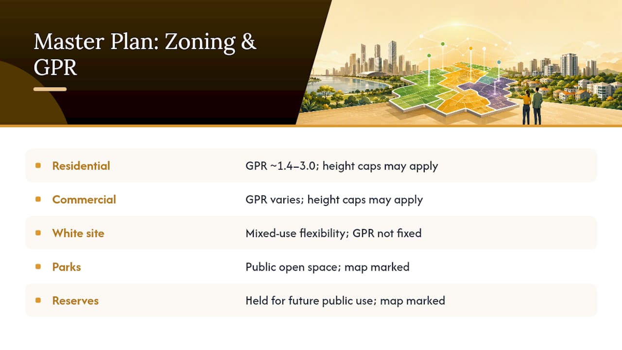
Height controls, conservation overlays, and notations like “subject to detailed planning” sit on top of the base zoning and can restrict or condition what the plot ratio alone would suggest. Roads, waterbodies, and reserve boundaries are marked too, since they affect setbacks and access.
None of this is exhaustive on its own. The Written Statement defines these zoning terms precisely, explains plot ratio interpretation, and lays out the development control provisions the map cannot show visually.
Pro Tip: A GPR around 1.4 typically points to low-rise landed or walk-up development, while higher values usually signal high-rise potential, subject to height caps and site-specific conditions, as Ace Mortgage notes in its buyer-facing breakdown of GPR figures.
How Often Is the Master Plan Reviewed and Made Official?
The Master Plan translates URA’s broader Long-Term Plan into parcel-level rules and is reviewed roughly every five years, with the current cycle covering the next 10 to 15 years of development. The process moves through distinct stages before anything is legally binding.
- URA prepares a Draft Master Plan reflecting updated regional strategies and demand projections.
- The draft goes on public exhibition, during which residents, businesses, and industry groups submit feedback.
- URA and partner agencies review submissions and adjust zoning, housing allocations, and conservation boundaries where warranted.
- The plan is finalized and gazetted, at which point it becomes the statutory reference for approvals.
Master Plan 2025 followed this path through what URA described as its largest public engagement effort to date, reaching a very large number of people before gazettal. Amendments take legal effect from the date of the Minister’s approval, and the Written Statement spells out how pending applications are treated when a plan changes mid-process.
How Do You Read a Site on URA Space?
URA Space is the free public portal where the Master Plan map actually lives, and working through it methodically saves you from misreading a parcel.
- Open URA Space and search the address or postal code of the parcel you’re assessing.
- Click directly on the parcel to open its detail panel.
- Read the zoning classification and the Gross Plot Ratio listed for that specific site.
- Check for height control figures and any overlay notations, such as conservation status or “subject to detailed planning.”
- Follow the reference links through to the relevant Written Statement clause and any applicable SDCP.
A few habits make this faster. Use the Legend panel to decode zoning colors you don’t recognize immediately, and toggle between Master Plan layers to compare the current gazetted plan against draft revisions. The “Redevelop Site” view is particularly useful because it estimates achievable height and gross floor area based on the site’s current controls, which practical guides on reading URA Space flag as one of the more underused features on the portal.
Pro Tip: If you plan to bring findings to a consultant or authority, screenshot the full parcel detail panel, including the zoning code, GPR figure, height notation, and any overlay flags. That single image often answers half the questions a planning consultant would otherwise need to ask you.
What Does the Master Plan Mean for Owners and Developers in Practice?
Zoning and plot ratio numbers translate into real constraints once you move from research to an actual application. The gap between what the map shows and what gets approved usually comes down to a handful of overlapping factors.
- Permissible use dictates what you can even propose, regardless of how generous the plot ratio looks.
- Plot ratio caps and height limits set the outer boundary of buildable floor area, but they are ceilings, not entitlements.
- Setbacks, conservation overlays, and SDCPs can quietly reduce buildable area well below the headline GPR.
- Cross-agency requirements from bodies like NParks, NHB, or LTA can impose buffers, easements, or heritage conditions the zoning map never mentions.
Some sites carry incentive plot ratios, where the competent authority permits intensity above the base GPR in exchange for specific design or public-benefit commitments, but these are granted case by case rather than assumed. As ZeroABSD’s investor guide points out, comparing a site’s plot ratio and zoning against neighboring parcels, and against the previous Master Plan cycle, often reveals upzoning signals worth acting on before the broader market catches up.
Pro Tip: If a neighboring parcel just had its plot ratio raised or its zoning shifted toward commercial use, treat that as an early signal, not a guarantee, for your own site.

A Four-Step Checklist to Assess a Plot Before You Commit
Before making an offer or greenlighting a design brief, run every site through the same four checks.
- Confirm the zoning classification and Gross Plot Ratio listed for the exact parcel.
- Check height controls and any overlay notations attached to the site.
- Read the relevant clauses in the Written Statement and any linked SDCP.
- Flag cross-agency or conservation constraints that could limit the site regardless of its zoning.
Certain flags deserve extra scrutiny:
- “Subject to detailed planning” usually means final parameters are still being worked out and could shift.
- National monument or conservation status typically caps or forbids demolition and major structural change.
- Reserve site status often signals the land is held for future public infrastructure, not private development.
If any of these appear, your next move should be requesting a site-specific excerpt of the Written Statement from a URA officer or bringing in a consultant before you go further.
When Should You Bring in a Planning or Authority-Submission Consultant?
Complex sites, tight plot ratio margins, or overlapping agency requirements are exactly where a consultant earns their fee. Typical engagements include:
- Interpreting Master Plan zoning and Written Statement clauses against your specific proposal.
- Running feasibility studies and plot-ratio calculations before you commit to a design direction.
- Preparing feasibility sketches and structural or geotechnical design checks.
- Compiling and submitting authority packages to BCA, URA, HDB, SCDF, JTC, and related agencies.
Before engaging one, ask about their track record with your specific zoning category, their success rate on authority submissions, and what deliverables and timeline they commit to upfront; you might also explore options in Real Estate Mentorship in Singapore to build expertise in property investing and planning. A well-prepared submission package with clear documentation typically moves through review faster than one assembled reactively after a query from the authority.
What the Master Plan Can’t Tell You on Its Own
Checking both the map and the Written Statement before bidding on a site or committing capital is not optional diligence. It’s the difference between an informed offer and a costly assumption.
If plot ratio headroom is central to your investment case, verify the actual permitted intensity with a planning consultant early. Assuming the maximum GPR is automatically yours is one of the more expensive mistakes in Singapore property.
How Stellar Structures Helps You Act on Master Plan Findings
Reading URA Space tells you what a site might allow. Confirming what it will actually allow, and getting an authority to approve it, is a different job entirely. Stellar Structures works through that gap directly, running civil and structural design checks and preparing full authority submission packages for BCA, URA, HDB, SCDF, and JTC so a promising plot ratio on paper doesn’t stall at the approval stage.

Before reaching out, have the site address, postal code or parcel reference, current land-use notes, and any existing drawings or development proposals ready. That lets us move straight into a feasibility sketch and plot-ratio assessment rather than spending the first meeting gathering basics. Readers weighing residential redevelopment can also look at our residential design services for a sense of how zoning translates into an actual building brief. If you’re ready to test whether a site’s headroom is real or just theoretical, get in touch with Stellar Structures to start a feasibility check.
Frequently Asked Questions
What is the URA Master Plan in simple terms?
It’s Singapore’s statutory land-use plan, showing permitted development for each parcel over a 10 to 15 year horizon, reviewed roughly every five years.
Does the Master Plan guarantee I can build to the maximum plot ratio shown?
No. The plot ratio shown is a ceiling; the competent authority can set actual permitted intensity lower based on site context and detailed controls.
Where do I check zoning and plot ratio for a specific address?
Search the address on URA Space, click the parcel, and read the zoning classification and Gross Plot Ratio listed in the detail panel.
What’s the difference between the Master Plan map and the Written Statement?
The map shows zoning visually; the Written Statement provides the legal definitions, plot ratio interpretation, and development control rules behind it.
When should I hire a planning consultant instead of reading URA Space myself?
Bring in a consultant when your project depends on tight plot ratio margins, overlapping agency requirements, or unclear overlay notations you can’t resolve from the Written Statement alone.
Sources
Recommended
- Understanding the Masterplan URA: A Guide to Singapore’s Urban Future
- The Greater Southern Waterfront (GSW) Singapore
- Commercial Renovation Planning Guide for Owners – Stellar Structures
- Structural Challenges in Conserving and Restoring Singapore’s Heritage Shophouses