




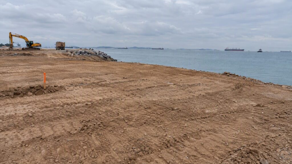
The commonly enforced minimum platform level (MPL) baseline across Singapore is 4.0 meters above the Singapore Height Datum (SHD) for developments along the southern coast and 4.5 meters SHD along the northern coast, or a relative-to-ground criterion where specified, whichever produces the higher elevation. Developers and qualified persons (QPs) must consult PUB’s Code of Practice on Coastal Protection and the Code of Practice on Surface Water Drainage, with Coastal Protection Level (CPL) computations endorsed by a Professional Engineer before Design Gateway submission.
TL;DR:
- A QP must use PUB parameters and set CPL at the highest of water level plus wave allowance, extreme sea level, or another specified level.
- Basement crests generally need 300 millimeters above MPL, while underground facilities and developments linked to them require 1.3 meters above adjacent road or ground level.
- Ports and airports target 5 meters or higher above mean sea level, while polders rely on dikes and pumps instead of raised platforms.
- Constrained sites may seek a section 73A waiver, but applications need survey evidence, technical justification, and proof that PUB accepts the remaining flood risk.
Table of Contents
- What minimum platform level means under Singapore’s flood defense framework
- Current Singapore standards: the numeric thresholds you need for design notes
- How CPL is computed and what the Design Gateway submission requires
- Site-specific treatment: reclaimed land, polders, and low-lying landed housing
- A practical checklist for meeting MPL requirements and preparing submissions
- Balancing compliance, cost, and buildability on MPL projects
- Stellar Structures services for MPL computations and authority submissions
- FAQ
- Sources
What minimum platform level means under Singapore’s flood defense framework
Minimum platform level refers to the lowest finished floor elevation permitted for a building or reclaimed site, set so that structures sit above anticipated flood and tidal extremes over their design life. We use the term alongside several related measures that appear throughout PUB and URA documentation, and project teams preparing submissions need to distinguish between them precisely.
Crest level describes the elevation of a protective feature, such as a dike, band or basement opening, rather than the platform itself. Coastal Protection Level (CPL) is the design benchmark PUB requires for coastal-facing sites, calculated from the design water level (DWL) plus a wave allowance (WA), or from the extreme sea level (ESL), whichever specified value is highest. Singapore Height Datum (SHD) is the national vertical reference against which all these figures are measured.
These definitions sit inside a wider planning logic PUB has described as the Source-Pathway-Receptor approach, detailed in recent guidance on stormwater management. The source is the rainfall or sea-level event itself; the pathway is the drainage or coastal route the water takes; the receptor is the building or land parcel that must withstand whatever reaches it. Given Singapore’s land constraints, upgrading every drainage pathway to handle worst-case events is not always feasible, so receptor measures like MPL carry a large share of the protective burden.
This is why MPL figures are not fixed forever. PUB’s own guidance on coastal protection notes that minimum reclamation and platform levels were raised from 3 meters to at least 4 meters above mean sea level since 2011, a policy shift tied directly to long-term sea-level projections. The Third National Climate Change Study projects that mean sea levels around Singapore could rise by up to approximately 1.15 meters by 2100, a figure that continues to drive periodic review of both platform levels and coastal protection standards.
The practical implications for design teams include:
- Every coastal or low-lying site needs a CPL computation before platform levels can be finalized on layout plans.
- Receptor measures like MPL are not a substitute for drainage upgrades but a complement to them where pathway improvements are constrained.
- Projected sea-level rise means a platform level compliant today may need to be revisited for sites with long development horizons.
Current Singapore standards: the numeric thresholds you need for design notes
Design teams preparing submissions need exact figures, not approximations, because these numbers appear directly in layout plans and QP endorsement letters.
The commonly applied MPL baseline is 4.0 meters SHD for the southern coast and 4.5 meters SHD for the northern coast, according to PUB’s coastal protection guidance, which also confirms that minimum reclamation and platform levels were raised from 3 meters to at least 4 meters above mean sea level since 2011. This uplift reflects a deliberate margining decision rather than a one-off correction, and it means older developments built to the previous 3-meter benchmark sit below the level expected of new submissions today.

Where a relative-to-ground criterion applies instead of an absolute SHD figure, typical requirements set the platform between 600 millimeters and 1.0 meter above the adjacent road or ground level. PUB and URA apply a “whichever is highest” rule across these criteria: a project team computes both the absolute SHD-based CPL and any relative-to-ground figure, then adopts whichever result sits higher.
Basements and underground facilities carry stricter buffers than the general platform:
- Basement crest levels are commonly required to sit at least 300 millimeters above the calculated MPL, a step up from an earlier 150-millimeter buffer referenced in PUB’s stormwater management materials.
- Underground facilities including MRT stations and road tunnels require a crest level of 1.3 meters above the adjacent road or ground level, a rule that extends to developments linking directly or indirectly to such infrastructure.
- Critical M&E equipment in key or critical infrastructure should be positioned at or above MPL, never below it, regardless of how the surrounding floor plate is configured.
Minimum reclamation and platform levels for new Singapore developments have stood at 4 meters or higher above mean sea level since the 2011 policy revision, up from the previous 3-meter benchmark, a change PUB attributes directly to long-term sea-level projections. Selected major infrastructure projects, including the Tuas Mega Port and Changi Terminal 5, are being planned at 5 meters or higher above mean sea level, reflecting the greater consequence of flooding at nationally significant facilities. QPs working on port, airport or other high-consequence infrastructure should treat 4 meters as a floor, not a target, and confirm project-specific minima with PUB before finalizing layout drawings.
How CPL is computed and what the Design Gateway submission requires
Computing the Coastal Protection Level is a QP-led technical exercise, and PUB’s Code of Practice on Coastal Protection (First Edition, June 2026) sets out exactly how the figure must be derived. CPL is taken as the highest of three possible values: the design water level plus wave allowance, the extreme sea level, or any other level PUB specifies for that site. The PE or QP must compute this using PUB-prescribed hydraulic boundary parameters rather than generic regional data, then indicate the resulting crest levels directly on layout plans submitted at Design Gateway.
The computation sequence a project team typically follows looks like this:
- Obtain PUB’s site-specific hydraulic boundary parameters for the coastal segment in question.
- Calculate the design water level and apply the prescribed wave allowance to arrive at DWL plus WA.
- Calculate the extreme sea level independently using the same prescribed parameters.
- Compare both results against any other level PUB has specified for the site, then adopt the highest value as CPL.
- Translate CPL into platform and crest levels on the layout plan, with the PE’s endorsement attached.
A complete Design Gateway submission package generally includes:
- The CPL computation itself, with all hydraulic inputs and assumptions documented.
- Layout plans showing crest levels and platform elevations at every relevant point on the site.
- The PE or QP’s endorsement confirming the computation methodology and resulting figures.
- Supporting hydraulic data, including any site-specific modeling PUB has requested.
Waiver or exemption routes exist under section 73A of the relevant legislation for sites where strict compliance with the standard CPL would be impractical or disproportionate, such as constrained urban infill plots or sites where adjacent infrastructure already sets a governing elevation. A waiver application needs to demonstrate why the standard computation produces an unreasonable outcome for that specific site, and it typically requires evidence such as survey data on adjacent ground levels, a technical justification for any landward adjustment to the Area Protection Boundary, and confirmation that residual flood risk has been assessed and is acceptable to PUB.
Reviewers commonly expect supporting documentation beyond the core computation, including topographic survey data, tidal and wave modeling outputs specific to the coastal segment, and a clear audit trail showing how the final platform level was derived from the raw hydraulic inputs. Our civil and structural design checks service supports project teams assembling this evidence base before submission, reducing the likelihood of a query cycle with PUB.
Site-specific treatment: reclaimed land, polders, and low-lying landed housing
Not every site follows the same platform-level logic, and Singapore’s recent large-scale projects illustrate how treatment diverges by site type.
The 2011 policy shift that raised minimum reclamation levels from 3 meters to at least 4 meters above mean sea level applies broadly to new reclaimed land, but ports and airports are held to a higher standard given the consequence of flooding at those sites. Our coastal engineering overview covers how these elevated minima interact with reclamation design more broadly.
Empoldering represents a distinct approach that departs from the “raise the platform” logic entirely. The Tekong polder project created reclaimed land sitting below mean sea level, protected instead by a coastal dike reaching up to 6 meters above mean sea level, with pumps and internal drainage managing water that collects inside the protected area. This method uses less sand than conventional reclamation to the same protective standard, but it shifts the compliance burden from platform elevation to dike integrity and pump system reliability, which demands a different submission and maintenance regime entirely.

Coastal barriers and tidal gates, under consideration for sites like the Long Island and Greater Southern Waterfront developments, change acceptable ground and platform practices again. Where a continuous line of coastal defense is planned, individual platform levels behind that barrier may eventually be set relative to the barrier’s protection standard rather than to open-sea extreme values, though this depends on how PUB’s site-specific studies for each segment conclude. Our coastal defense analysis walks through how these barrier-based approaches interact with adjacent road raising programs.
For landed housing in low-lying areas, URA’s circular on affected developments permits certain ancillary areas and setbacks to remain below full MPL where raising them would create awkward streetscape transitions with neighboring properties. This flexibility comes with conditions: the QP must endorse drawings confirming which areas qualify, and in some cases the developer must acknowledge in writing that those areas may need to be raised later if adjacent ground levels change.
- Reclaimed land for general development typically targets 4 meters SHD or higher as a floor, per the 2011 policy revision.
- Ports and airports are planned at 5 meters or higher given their consequence profile.
- Polder sites substitute dike and pump protection for platform elevation, changing the entire submission basis.
- Road buffer exemptions for landed housing require explicit QP endorsement and, often, a future-raising undertaking from the developer.
Pro Tip: Confirm early with PUB whether your site falls inside a planned coastal barrier segment, since that status can materially change which CPL inputs your QP should use.
A practical checklist for meeting MPL requirements and preparing submissions
Project teams that sequence their work correctly tend to clear PUB and URA review with fewer query rounds. We recommend the following sequence for any site where coastal or surface water flooding is a relevant consideration.
- Scan the site against PUB’s published coastal segments and any announced site-specific studies to confirm which hydraulic boundary parameters apply.
- Select the hydraulic inputs, pulling design water level, wave allowance and extreme sea level figures from PUB’s prescribed dataset for that segment rather than estimating them.
- Calculate CPL as the highest of DWL plus WA, ESL, or any other PUB-specified level, with the PE documenting every assumption.
- Set platform and crest levels on the layout plan, applying the 300-millimeter basement buffer and the 1.3-meter underground crest rule where those conditions apply.
- Secure QP endorsement on the computation and the resulting drawings before the package moves to Design Gateway.
- Assemble the Design Gateway package, including hydraulic data, survey information and the endorsed computation.
- Prepare a conditions or waiver plan in parallel, in case the site qualifies for a section 73A exemption or requires a landward APB adjustment.
Placement decisions for M&E equipment and critical infrastructure deserve attention early rather than at the services coordination stage. Equipment serving key or critical functions should sit at or above MPL from the first floor plan iteration, and basement entry points need threshold details that reflect the 300-millimeter crest buffer rather than a generic damp-proofing allowance. Drainage tie-ins into the public system should be coordinated against PUB’s surface water drainage code at the same time as the coastal computation, since the two submissions often review in parallel; our stormwater management workflow outlines how to sequence these clearances without one holding up the other.
PUB and URA reviewers consistently look for a clear, traceable line from hydraulic inputs to final platform figures, so documentation that shows the calculation steps explicitly tends to move faster than a package presenting only the final number. Reviewers also commonly query how a site’s drainage submission connects to its coastal computation, which is worth pre-empting with a short cross-reference note in the submission package; our PUB drainage submission guide covers the documentation reviewers expect to see together.
Pro Tip: Build in a margin above the computed MPL where the site sits near a road PUB has flagged for future raising, since retrofitting a platform after construction is far costlier than designing for it upfront.
Construction-phase site conditions matter too: earthworks and reclamation activity on low-lying or waterlogged sites can create standing water that attracts mosquito breeding, and maintaining a compliant site during the works is worth coordinating alongside platform-level planning; NEA audit-ready site compliance guidance from our pest management partner covers this alongside other construction-site obligations.
Balancing compliance, cost, and buildability on MPL projects
Meeting a minimum platform level requirement is never just a box to check against a single number. Every project we work on treats the CPL computation as the starting point for a broader conversation about buildability: how foundation design, basement waterproofing and M&E routing all respond to the elevation a QP ultimately certifies.
We bring the Professional Engineer into the project early, often before the architectural layout is fixed, so hydraulic inputs inform the design rather than forcing a late rework. We coordinate submissions to relevant authorities simultaneously where a project touches more than one, because sequencing these in isolation is where delays commonly originate. Margining decisions, including how far above the computed minimum a platform should sit, get made with the full construction program in view, not just the regulatory floor.
This work draws on structural and geotechnical consulting, design checks, and periodic inspection services, applied together rather than as separate engagements. For project-specific guidance on your site’s platform level requirements, reach out to a specialized team directly.
— Aman
Stellar Structures services for MPL computations and authority submissions
Setting and defending a minimum platform level is a technical exercise with real cost consequences if it is rushed or handled in isolation from the rest of your design. Support is provided to project teams through the full sequence: hydraulic input selection, CPL computation, layout plan preparation, and submission package preparation to relevant authorities, coordinated alongside other necessary approvals where projects require them.
Getting started typically means sharing your site survey, any existing geotechnical reports, and a preliminary layout so our engineers can scope the hydraulic parameters your site falls under. From there, we deliver an endorsed CPL computation, finalized platform and crest levels on your layout drawings, and a submission package structured to PUB and URA expectations.
- PUB submissions: coastal protection and drainage clearances handled alongside your platform-level computation.
- Civil and structural design checks: verification of how your platform level decisions translate into foundation and structural design.
- BCA and URA submission support: coordinated authority approvals so your MPL submission does not stall against other statutory requirements.
- BCA periodic structural inspection: ongoing compliance checks once your development is built and occupied.
Reach out to our team to scope your site’s requirements before your next submission deadline.
FAQ
What is the minimum platform level in Singapore?
The commonly enforced minimum platform level is 4.0 meters SHD for southern coast developments and 4.5 meters SHD for northern coast developments, or a relative-to-ground alternative where specified, whichever is higher. This baseline reflects the 2011 policy revision that raised minimum reclamation and platform levels from 3 meters to at least 4 meters above mean sea level, as described in PUB’s coastal protection guidance.
How is the Coastal Protection Level calculated?
CPL is calculated as the highest of three values: the design water level plus a wave allowance, the extreme sea level, or any other level PUB specifies for the site, using PUB-prescribed hydraulic boundary parameters. A Professional Engineer or Qualified Person must perform this computation and endorse the resulting crest levels before Design Gateway submission.
Is Singapore’s sea level rising?
Yes. National climate projections indicate mean sea levels around Singapore could rise by up to approximately 1.15 meters by 2100, a figure that has already driven policy changes to reclamation and platform level minima, according to NCCS coastal protection data.
What crest level applies to basements and underground facilities?
Basement crest levels are commonly required to sit at least 300 millimeters above the calculated minimum platform level. Underground facilities such as MRT stations and road tunnels require a crest level of 1.3 meters above the adjacent road or ground level, a rule that also applies to developments linking to such infrastructure.
Can a development get a waiver from standard minimum platform level requirements?
Yes, waiver or exemption routes exist under section 73A for sites where strict compliance is impractical, such as constrained infill plots. An application needs survey evidence, technical justification for any landward adjustment, and confirmation that residual flood risk is acceptable to PUB.
Sources
- Code of Practice on Coastal Protection (First Edition June 2026)
- Guidelines for New Landed Housing Developments Affected By Minimum Platform Level Requirements in Low-Lying Areas | URA
Recommended
- SCDF Mezzanine Requirements: Fire Code 2023 & BCA Guide
- Mezzanine Floor Approval Guide Singapore 2026
- Illegal Mezzanine Floors in Singapore: Penalties, Risks, and Solutions
- How to Regularize an Unapproved Mezzanine Floor in Singapore